You are here: Home > Network List > TD - TransAlta Monitoring Network Stations List
> Station TD013 Z > Earthquake Result Viewer
TD013 Z - Earthquake Result Viewer
| Earthquake location: |
Komandorskiye Ostrova Region |
| Earthquake latitude/longitude: |
54.8/164.8 |
| Earthquake time(UTC): |
2018/12/20 (354) 17:01:56 GMT |
| Earthquake Depth: |
33 km |
| Earthquake Magnitude: |
7.3 Mi |
| Earthquake Catalog/Contributor: |
NEIC PDE/pt |
|
| Network: |
TD TransAlta Monitoring Network |
| Station: |
TD013 Z |
| Lat/Lon: |
52.52 N/115.02 W |
| Elevation: |
975 m |
|
| Distance: |
45.1 deg |
| Az: |
58.256 deg |
| Baz: |
306.408 deg |
| Ray Param: |
0.07145212 |
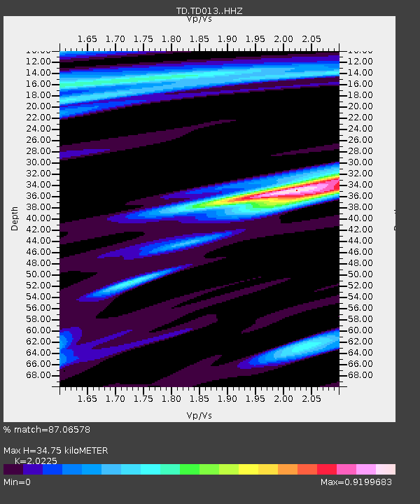
| Estimated Moho Depth: |
34.75 km |
| Estimated Crust Vp/Vs: |
2.02 |
| Assumed Crust Vp: |
6.426 km/s |
| Estimated Crust Vs: |
3.177 km/s |
| Estimated Crust Poisson's Ratio: |
0.34 |
|
| Radial Match: |
87.06578 % |
| Radial Bump: |
330 |
| Transverse Match: |
79.53182 % |
| Transverse Bump: |
400 |
| SOD ConfigId: |
13570011 |
| Insert Time: |
2019-05-02 02:25:30.696 +0000 |
| GWidth: |
2.5 |
| Max Bumps: |
400 |
| Tol: |
0.001 |
|

Signal To Noise
| Channel | StoN | STA | LTA |
| TD:TD013: :HHZ:20181220T17:09:38.73999Z | 6.9743714 | 8.210708E-6 | 1.1772686E-6 |
| TD:TD013: :HH1:20181220T17:09:38.73999Z | 1.4859952 | 2.1872954E-6 | 1.4719398E-6 |
| TD:TD013: :HH2:20181220T17:09:38.73999Z | 0.9069134 | 1.124015E-6 | 1.239385E-6 |
| Arrivals |
| Ps | 5.8 SECOND |
| PpPs | 15 SECOND |
| PsPs/PpSs | 21 SECOND |


