You are here: Home > Network List > TJ - Tajikistan National Seismic Network Stations List
> Station IGRN Igron, Tajikistan > Earthquake Result Viewer
IGRN Igron, Tajikistan - Earthquake Result Viewer
| Earthquake location: |
Komandorskiye Ostrova Region |
| Earthquake latitude/longitude: |
54.8/164.8 |
| Earthquake time(UTC): |
2018/12/20 (354) 17:01:56 GMT |
| Earthquake Depth: |
33 km |
| Earthquake Magnitude: |
7.3 Mi |
| Earthquake Catalog/Contributor: |
NEIC PDE/pt |
|
| Network: |
TJ Tajikistan National Seismic Network |
| Station: |
IGRN Igron, Tajikistan |
| Lat/Lon: |
38.22 N/69.33 E |
| Elevation: |
1284 m |
|
| Distance: |
62.7 deg |
| Az: |
298.059 deg |
| Baz: |
40.386 deg |
| Ray Param: |
0.060014397 |
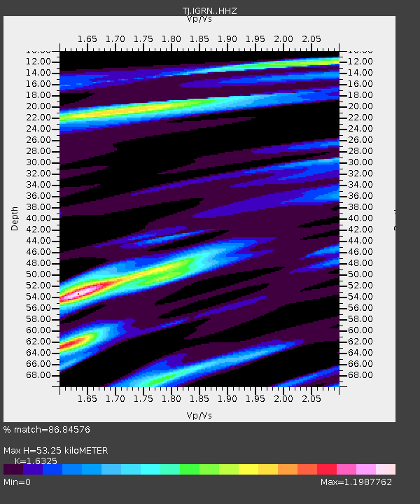
| Estimated Moho Depth: |
53.25 km |
| Estimated Crust Vp/Vs: |
1.63 |
| Assumed Crust Vp: |
6.483 km/s |
| Estimated Crust Vs: |
3.971 km/s |
| Estimated Crust Poisson's Ratio: |
0.20 |
|
| Radial Match: |
86.84576 % |
| Radial Bump: |
358 |
| Transverse Match: |
78.49135 % |
| Transverse Bump: |
400 |
| SOD ConfigId: |
13570011 |
| Insert Time: |
2019-05-02 02:25:36.530 +0000 |
| GWidth: |
2.5 |
| Max Bumps: |
400 |
| Tol: |
0.001 |
|

Signal To Noise
| Channel | StoN | STA | LTA |
| TJ:IGRN: :HHZ:20181220T17:11:46.559998Z | 75.147675 | 1.633189E-5 | 2.173306E-7 |
| TJ:IGRN: :HHN:20181220T17:11:46.559998Z | 24.658056 | 5.4986267E-6 | 2.2299514E-7 |
| TJ:IGRN: :HHE:20181220T17:11:46.559998Z | 22.474415 | 3.983102E-6 | 1.7722827E-7 |
| Arrivals |
| Ps | 5.5 SECOND |
| PpPs | 21 SECOND |
| PsPs/PpSs | 26 SECOND |


