You are here: Home > Network List > TS - TERRAscope (Southern California Seismic Network) Stations List
> Station BAR Barrett Dam, California, USA > Earthquake Result Viewer
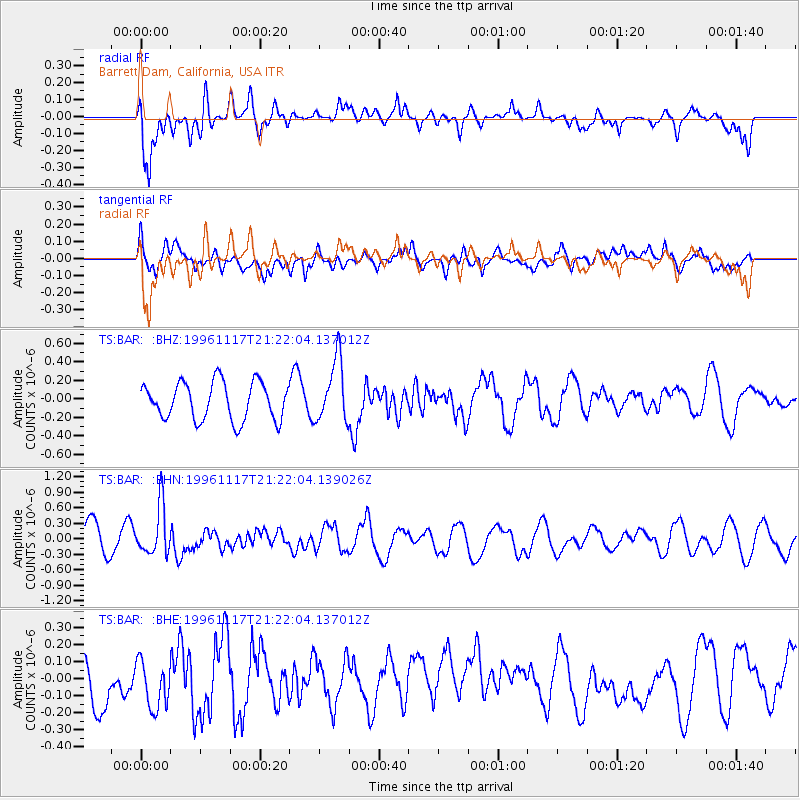
BAR Barrett Dam, California, USA - Earthquake Result Viewer
*The percent match for this event was below the threshold and hence no stack was calculated.
| Earthquake location: |
South Of Fiji Islands |
| Earthquake latitude/longitude: |
-22.2/-179.7 |
| Earthquake time(UTC): |
1996/11/17 (322) 21:11:20 GMT |
| Earthquake Depth: |
592 km |
| Earthquake Magnitude: |
5.5 MB, 6.1 UNKNOWN, 6.0 MW |
| Earthquake Catalog/Contributor: |
WHDF/NEIC |
|
| Network: |
TS TERRAscope (Southern California Seismic Network) |
| Station: |
BAR Barrett Dam, California, USA |
| Lat/Lon: |
32.68 N/116.67 W |
| Elevation: |
548 m |
|
| Distance: |
81.2 deg |
| Az: |
49.512 deg |
| Baz: |
236.698 deg |
| Ray Param: |
$rayparam |
*The percent match for this event was below the threshold and hence was not used in the summary stack. |
|
| Radial Match: |
74.72838 % |
| Radial Bump: |
400 |
| Transverse Match: |
63.063328 % |
| Transverse Bump: |
400 |
| SOD ConfigId: |
4480 |
| Insert Time: |
2010-02-26 14:02:05.417 +0000 |
| GWidth: |
2.5 |
| Max Bumps: |
400 |
| Tol: |
0.001 |
|
Signal To Noise
| Channel | StoN | STA | LTA |
| TS:BAR: :BHN:19961117T21:22:04.139026Z | 1.6153362 | 4.762286E-7 | 2.94817E-7 |
| TS:BAR: :BHE:19961117T21:22:04.137012Z | 0.7962574 | 1.4735858E-7 | 1.85064E-7 |
| TS:BAR: :BHZ:19961117T21:22:04.137012Z | 1.6597728 | 3.3573113E-7 | 2.0227537E-7 |
| Arrivals |
| Ps | |
| PpPs | |
| PsPs/PpSs | |


