You are here: Home > Network List > UW - Pacific Northwest Regional Seismic Network Stations List
> Station UMAT Pilot Rock, OR, USA > Earthquake Result Viewer
UMAT Pilot Rock, OR, USA - Earthquake Result Viewer
| Earthquake location: |
Komandorskiye Ostrova Region |
| Earthquake latitude/longitude: |
54.8/164.8 |
| Earthquake time(UTC): |
2018/12/20 (354) 17:01:56 GMT |
| Earthquake Depth: |
33 km |
| Earthquake Magnitude: |
7.3 Mi |
| Earthquake Catalog/Contributor: |
NEIC PDE/pt |
|
| Network: |
UW Pacific Northwest Regional Seismic Network |
| Station: |
UMAT Pilot Rock, OR, USA |
| Lat/Lon: |
45.29 N/118.96 W |
| Elevation: |
1318 m |
|
| Distance: |
47.5 deg |
| Az: |
68.33 deg |
| Baz: |
310.415 deg |
| Ray Param: |
0.069862805 |
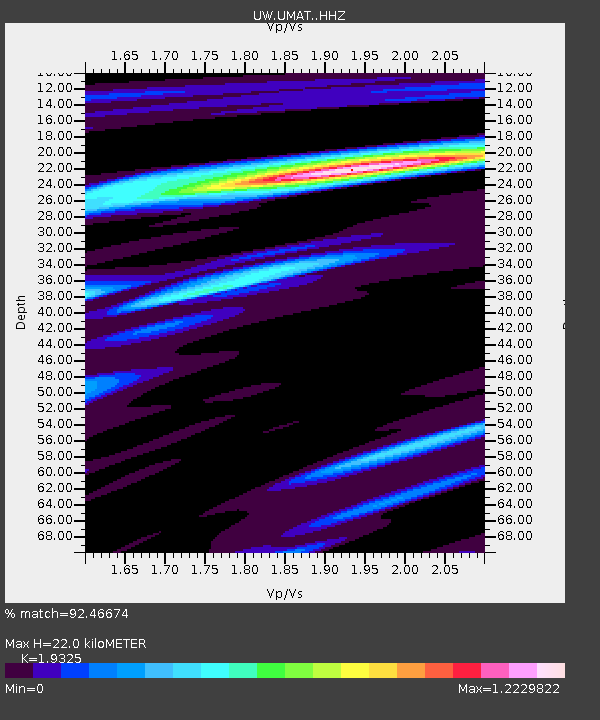
| Estimated Moho Depth: |
22.0 km |
| Estimated Crust Vp/Vs: |
1.93 |
| Assumed Crust Vp: |
6.571 km/s |
| Estimated Crust Vs: |
3.4 km/s |
| Estimated Crust Poisson's Ratio: |
0.32 |
|
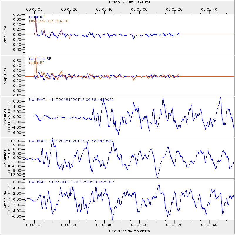
| Radial Match: |
92.46674 % |
| Radial Bump: |
303 |
| Transverse Match: |
76.67802 % |
| Transverse Bump: |
400 |
| SOD ConfigId: |
13570011 |
| Insert Time: |
2019-05-02 02:26:50.580 +0000 |
| GWidth: |
2.5 |
| Max Bumps: |
400 |
| Tol: |
0.001 |
|
Signal To Noise
| Channel | StoN | STA | LTA |
| UW:UMAT: :HHZ:20181220T17:09:58.447998Z | 2.565972 | 2.3348848E-6 | 9.099416E-7 |
| UW:UMAT: :HHN:20181220T17:09:58.447998Z | 2.1554477 | 1.1661386E-6 | 5.410193E-7 |
| UW:UMAT: :HHE:20181220T17:09:58.447998Z | 2.5575635 | 1.2114107E-6 | 4.7365808E-7 |
| Arrivals |
| Ps | 3.3 SECOND |
| PpPs | 9.3 SECOND |
| PsPs/PpSs | 13 SECOND |


