You are here: Home > Network List > WU - The Southern Ontario Seismic Network Stations List
> Station KLBO Killbear Provincial Park, Ontario, Canada > Earthquake Result Viewer
KLBO Killbear Provincial Park, Ontario, Canada - Earthquake Result Viewer
| Earthquake location: |
Komandorskiye Ostrova Region |
| Earthquake latitude/longitude: |
54.8/164.8 |
| Earthquake time(UTC): |
2018/12/20 (354) 17:01:56 GMT |
| Earthquake Depth: |
33 km |
| Earthquake Magnitude: |
7.3 Mi |
| Earthquake Catalog/Contributor: |
NEIC PDE/pt |
|
| Network: |
WU The Southern Ontario Seismic Network |
| Station: |
KLBO Killbear Provincial Park, Ontario, Canada |
| Lat/Lon: |
45.36 N/80.21 W |
| Elevation: |
177 m |
|
| Distance: |
66.0 deg |
| Az: |
44.397 deg |
| Baz: |
324.981 deg |
| Ray Param: |
0.057838734 |
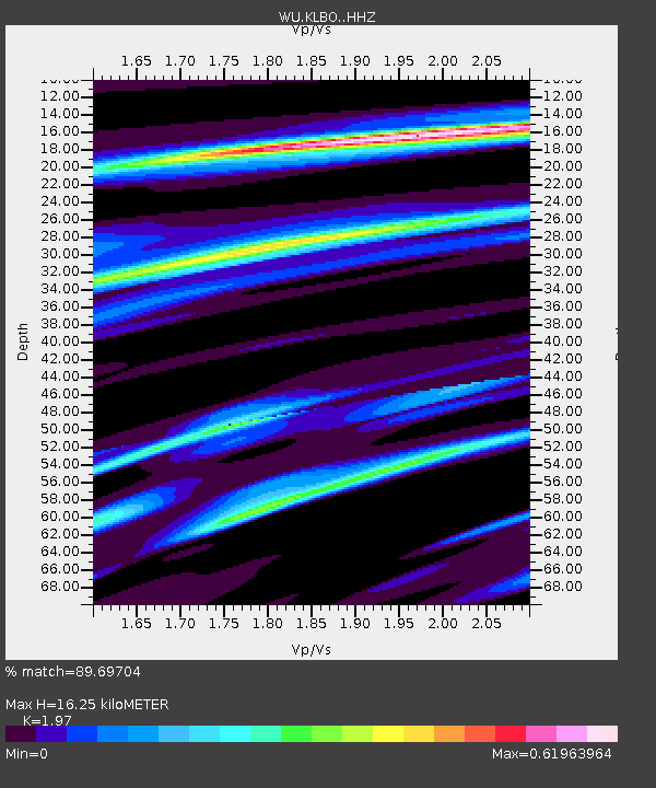
| Estimated Moho Depth: |
16.25 km |
| Estimated Crust Vp/Vs: |
1.97 |
| Assumed Crust Vp: |
6.53 km/s |
| Estimated Crust Vs: |
3.315 km/s |
| Estimated Crust Poisson's Ratio: |
0.33 |
|
| Radial Match: |
89.69704 % |
| Radial Bump: |
277 |
| Transverse Match: |
73.75878 % |
| Transverse Bump: |
373 |
| SOD ConfigId: |
13570011 |
| Insert Time: |
2019-05-02 02:27:06.443 +0000 |
| GWidth: |
2.5 |
| Max Bumps: |
400 |
| Tol: |
0.001 |
|

Signal To Noise
| Channel | StoN | STA | LTA |
| WU:KLBO: :HHZ:20181220T17:12:08.77002Z | 3.2117121 | 3.969098E-6 | 1.2358199E-6 |
| WU:KLBO: :HHN:20181220T17:12:08.77002Z | 1.6694089 | 1.5171098E-6 | 9.087707E-7 |
| WU:KLBO: :HHE:20181220T17:12:08.77002Z | 1.3694621 | 9.977132E-7 | 7.285438E-7 |
| Arrivals |
| Ps | 2.5 SECOND |
| PpPs | 7.1 SECOND |
| PsPs/PpSs | 9.6 SECOND |


