You are here: Home > Network List > TA - USArray Transportable Network (new EarthScope stations) Stations List
> Station V19A Window Rock, AZ, USA > Earthquake Result Viewer
V19A Window Rock, AZ, USA - Earthquake Result Viewer
| Earthquake location: |
East Of Kuril Islands |
| Earthquake latitude/longitude: |
46.9/155.2 |
| Earthquake time(UTC): |
2009/01/15 (015) 17:49:39 GMT |
| Earthquake Depth: |
36 km |
| Earthquake Magnitude: |
6.9 MB, 7.5 MS, 7.4 MW, 7.4 MW |
| Earthquake Catalog/Contributor: |
WHDF/NEIC |
|
| Network: |
TA USArray Transportable Network (new EarthScope stations) |
| Station: |
V19A Window Rock, AZ, USA |
| Lat/Lon: |
35.71 N/109.05 W |
| Elevation: |
2082 m |
|
| Distance: |
68.5 deg |
| Az: |
60.468 deg |
| Baz: |
312.799 deg |
| Ray Param: |
0.056195628 |
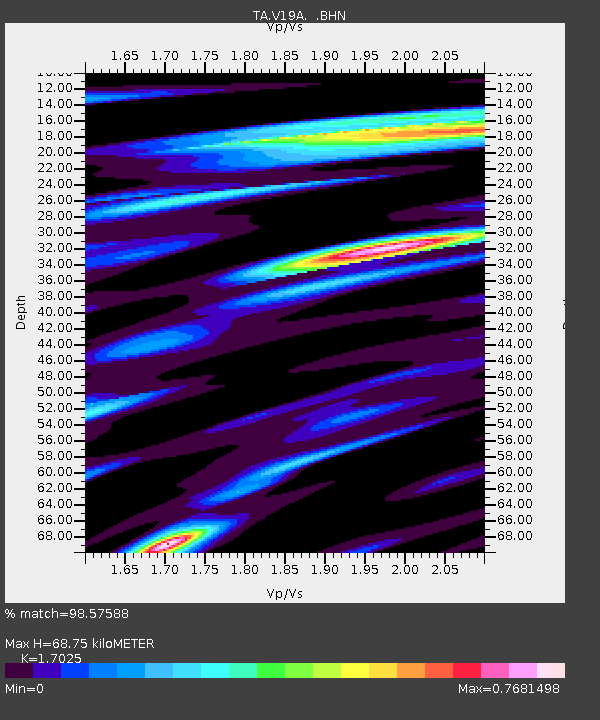
| Estimated Moho Depth: |
68.75 km |
| Estimated Crust Vp/Vs: |
1.70 |
| Assumed Crust Vp: |
6.496 km/s |
| Estimated Crust Vs: |
3.816 km/s |
| Estimated Crust Poisson's Ratio: |
0.24 |
|
| Radial Match: |
98.57588 % |
| Radial Bump: |
377 |
| Transverse Match: |
95.5803 % |
| Transverse Bump: |
400 |
| SOD ConfigId: |
2834 |
| Insert Time: |
2010-03-06 18:45:15.469 +0000 |
| GWidth: |
2.5 |
| Max Bumps: |
400 |
| Tol: |
0.001 |
|
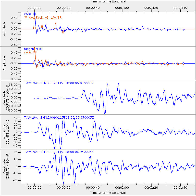
Signal To Noise
| Channel | StoN | STA | LTA |
| TA:V19A: :BHN:20090115T18:00:06.950005Z | 53.81644 | 1.2654693E-5 | 2.3514548E-7 |
| TA:V19A: :BHE:20090115T18:00:06.950005Z | 14.641881 | 4.2613E-6 | 2.91035E-7 |
| TA:V19A: :BHZ:20090115T18:00:06.950005Z | 11.413398 | 4.395193E-6 | 3.8509066E-7 |
| Arrivals |
| Ps | 7.7 SECOND |
| PpPs | 27 SECOND |
| PsPs/PpSs | 35 SECOND |


