You are here: Home > Network List > US - United States National Seismic Network Stations List
> Station OGNE Ogallala, Nebraska, USA > Earthquake Result Viewer
OGNE Ogallala, Nebraska, USA - Earthquake Result Viewer
| Earthquake location: |
North Of Ascension Island |
| Earthquake latitude/longitude: |
-0.0/-17.8 |
| Earthquake time(UTC): |
2016/08/29 (242) 04:29:57 GMT |
| Earthquake Depth: |
10 km |
| Earthquake Magnitude: |
7.1 MWW, 7.1 MWC, 7.4 MI |
| Earthquake Catalog/Contributor: |
NEIC PDE/NEIC COMCAT |
|
| Network: |
US United States National Seismic Network |
| Station: |
OGNE Ogallala, Nebraska, USA |
| Lat/Lon: |
40.95 N/102.03 W |
| Elevation: |
1054 m |
|
| Distance: |
85.6 deg |
| Az: |
310.903 deg |
| Baz: |
93.827 deg |
| Ray Param: |
0.04461731 |
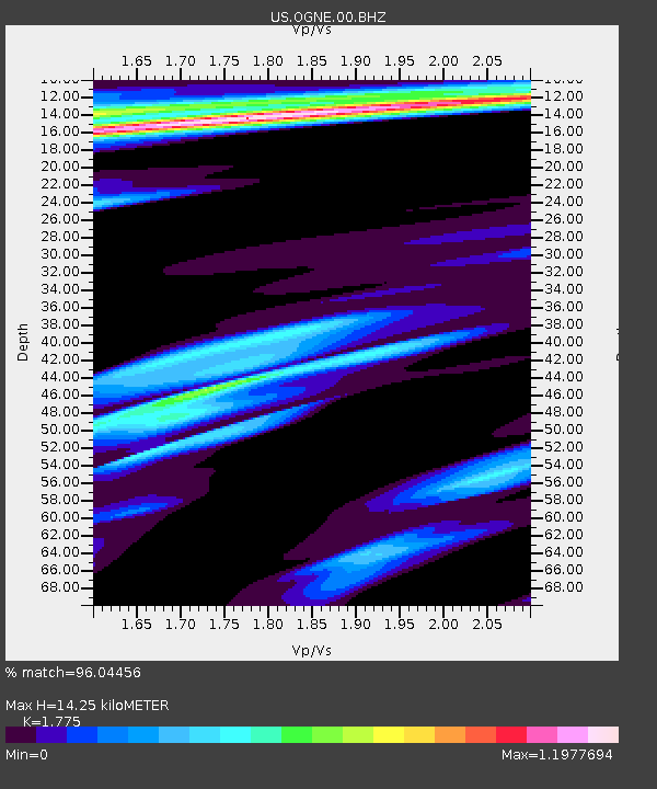
| Estimated Moho Depth: |
14.25 km |
| Estimated Crust Vp/Vs: |
1.77 |
| Assumed Crust Vp: |
6.483 km/s |
| Estimated Crust Vs: |
3.652 km/s |
| Estimated Crust Poisson's Ratio: |
0.27 |
|
| Radial Match: |
96.04456 % |
| Radial Bump: |
342 |
| Transverse Match: |
91.1124 % |
| Transverse Bump: |
325 |
| SOD ConfigId: |
1634031 |
| Insert Time: |
2016-09-12 04:35:27.985 +0000 |
| GWidth: |
2.5 |
| Max Bumps: |
400 |
| Tol: |
0.001 |
|
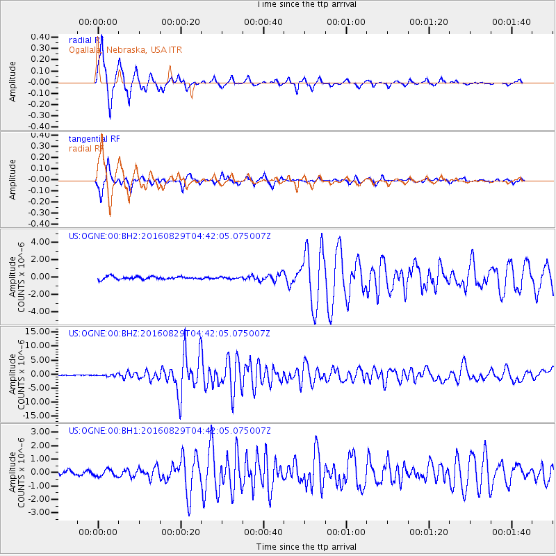
Signal To Noise
| Channel | StoN | STA | LTA |
| US:OGNE:00:BHZ:20160829T04:42:05.075007Z | 3.30055 | 3.3901276E-7 | 1.0271402E-7 |
| US:OGNE:00:BH1:20160829T04:42:05.075007Z | 2.241234 | 2.565445E-7 | 1.1446573E-7 |
| US:OGNE:00:BH2:20160829T04:42:05.075007Z | 0.6143353 | 9.495976E-8 | 1.5457319E-7 |
| Arrivals |
| Ps | 1.7 SECOND |
| PpPs | 6.0 SECOND |
| PsPs/PpSs | 7.7 SECOND |


