You are here: Home > Network List > US - United States National Seismic Network Stations List
> Station VBMS Vicksburg, Mississippi > Earthquake Result Viewer
VBMS Vicksburg, Mississippi - Earthquake Result Viewer
| Earthquake location: |
North Of Ascension Island |
| Earthquake latitude/longitude: |
-0.0/-17.8 |
| Earthquake time(UTC): |
2016/08/29 (242) 04:29:57 GMT |
| Earthquake Depth: |
10 km |
| Earthquake Magnitude: |
7.1 MWW, 7.1 MWC, 7.4 MI |
| Earthquake Catalog/Contributor: |
NEIC PDE/NEIC COMCAT |
|
| Network: |
US United States National Seismic Network |
| Station: |
VBMS Vicksburg, Mississippi |
| Lat/Lon: |
32.22 N/90.52 W |
| Elevation: |
16 m |
|
| Distance: |
75.4 deg |
| Az: |
303.262 deg |
| Baz: |
99.431 deg |
| Ray Param: |
0.051683918 |
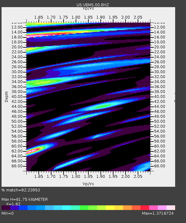
| Estimated Moho Depth: |
61.75 km |
| Estimated Crust Vp/Vs: |
1.62 |
| Assumed Crust Vp: |
6.201 km/s |
| Estimated Crust Vs: |
3.828 km/s |
| Estimated Crust Poisson's Ratio: |
0.19 |
|
| Radial Match: |
92.23953 % |
| Radial Bump: |
400 |
| Transverse Match: |
85.50178 % |
| Transverse Bump: |
400 |
| SOD ConfigId: |
1634031 |
| Insert Time: |
2016-09-12 04:35:37.405 +0000 |
| GWidth: |
2.5 |
| Max Bumps: |
400 |
| Tol: |
0.001 |
|
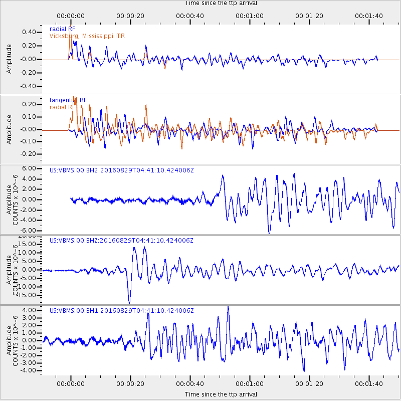
Signal To Noise
| Channel | StoN | STA | LTA |
| US:VBMS:00:BHZ:20160829T04:41:10.424006Z | 2.774471 | 5.0366646E-7 | 1.8153604E-7 |
| US:VBMS:00:BH1:20160829T04:41:10.424006Z | 0.90863657 | 2.4751247E-7 | 2.7239986E-7 |
| US:VBMS:00:BH2:20160829T04:41:10.424006Z | 1.2851905 | 3.325734E-7 | 2.587736E-7 |
| Arrivals |
| Ps | 6.4 SECOND |
| PpPs | 25 SECOND |
| PsPs/PpSs | 32 SECOND |


