You are here: Home > Network List > HV - Hawaiian Volcano Observatory Network Stations List
> Station MLOD Mauna Loa, Hawaii Digital > Earthquake Result Viewer
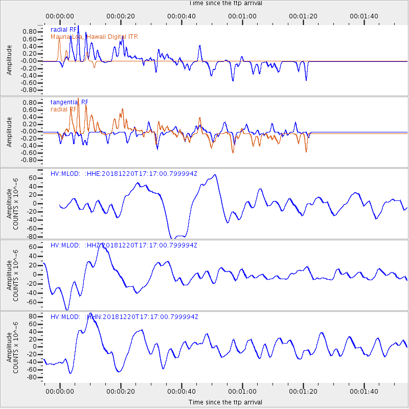
MLOD Mauna Loa, Hawaii Digital - Earthquake Result Viewer
*The percent match for this event was below the threshold and hence no stack was calculated.
| Earthquake location: |
Komandorskiye Ostrova Region |
| Earthquake latitude/longitude: |
54.9/164.8 |
| Earthquake time(UTC): |
2018/12/20 (354) 17:09:04 GMT |
| Earthquake Depth: |
10 km |
| Earthquake Magnitude: |
5.9 mb |
| Earthquake Catalog/Contributor: |
NEIC PDE/us |
|
| Network: |
HV Hawaiian Volcano Observatory Network |
| Station: |
MLOD Mauna Loa, Hawaii Digital |
| Lat/Lon: |
19.49 N/155.39 W |
| Elevation: |
2044 m |
|
| Distance: |
46.4 deg |
| Az: |
123.478 deg |
| Baz: |
329.291 deg |
| Ray Param: |
$rayparam |
*The percent match for this event was below the threshold and hence was not used in the summary stack. |
|
| Radial Match: |
62.203014 % |
| Radial Bump: |
400 |
| Transverse Match: |
83.52594 % |
| Transverse Bump: |
400 |
| SOD ConfigId: |
13570011 |
| Insert Time: |
2019-05-02 02:31:21.450 +0000 |
| GWidth: |
2.5 |
| Max Bumps: |
400 |
| Tol: |
0.001 |
|
Signal To Noise
| Channel | StoN | STA | LTA |
| HV:MLOD: :HHZ:20181220T17:17:00.799994Z | 4.504135 | 5.4692347E-5 | 1.2142697E-5 |
| HV:MLOD: :HHN:20181220T17:17:00.799994Z | 2.884737 | 5.2313408E-5 | 1.813455E-5 |
| HV:MLOD: :HHE:20181220T17:17:00.799994Z | 1.6502998 | 2.6737776E-5 | 1.6201768E-5 |
| Arrivals |
| Ps | |
| PpPs | |
| PsPs/PpSs | |


