You are here: Home > Network List > TA - USArray Transportable Network (new EarthScope stations) Stations List
> Station V19A Window Rock, AZ, USA > Earthquake Result Viewer
V19A Window Rock, AZ, USA - Earthquake Result Viewer
| Earthquake location: |
South Of Mariana Islands |
| Earthquake latitude/longitude: |
10.5/145.7 |
| Earthquake time(UTC): |
2007/09/30 (273) 02:08:30 GMT |
| Earthquake Depth: |
14 km |
| Earthquake Magnitude: |
6.4 MB, 7.1 MS, 6.9 MW, 6.9 MW |
| Earthquake Catalog/Contributor: |
WHDF/NEIC |
|
| Network: |
TA USArray Transportable Network (new EarthScope stations) |
| Station: |
V19A Window Rock, AZ, USA |
| Lat/Lon: |
35.71 N/109.05 W |
| Elevation: |
2082 m |
|
| Distance: |
96.1 deg |
| Az: |
52.148 deg |
| Baz: |
287.374 deg |
| Ray Param: |
0.040614463 |
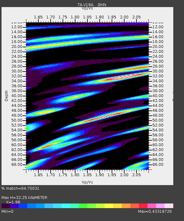
| Estimated Moho Depth: |
32.25 km |
| Estimated Crust Vp/Vs: |
1.99 |
| Assumed Crust Vp: |
6.496 km/s |
| Estimated Crust Vs: |
3.264 km/s |
| Estimated Crust Poisson's Ratio: |
0.33 |
|
| Radial Match: |
84.70031 % |
| Radial Bump: |
400 |
| Transverse Match: |
70.29298 % |
| Transverse Bump: |
400 |
| SOD ConfigId: |
2564 |
| Insert Time: |
2010-03-06 18:45:41.505 +0000 |
| GWidth: |
2.5 |
| Max Bumps: |
400 |
| Tol: |
0.001 |
|
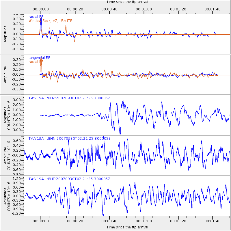
Signal To Noise
| Channel | StoN | STA | LTA |
| TA:V19A: :BHN:20070930T02:21:25.300005Z | 0.4533934 | 7.401517E-8 | 1.6324712E-7 |
| TA:V19A: :BHE:20070930T02:21:25.300005Z | 0.9095953 | 1.2917208E-7 | 1.4201049E-7 |
| TA:V19A: :BHZ:20070930T02:21:25.300005Z | 2.1822155 | 2.5151735E-7 | 1.152578E-7 |
| Arrivals |
| Ps | 5.0 SECOND |
| PpPs | 15 SECOND |
| PsPs/PpSs | 20 SECOND |


