You are here: Home > Network List > TA - USArray Transportable Network (new EarthScope stations) Stations List
> Station V19A Window Rock, AZ, USA > Earthquake Result Viewer
V19A Window Rock, AZ, USA - Earthquake Result Viewer
| Earthquake location: |
Near Coast Of Peru |
| Earthquake latitude/longitude: |
-13.6/-76.6 |
| Earthquake time(UTC): |
2007/08/19 (231) 01:22:40 GMT |
| Earthquake Depth: |
26 km |
| Earthquake Magnitude: |
5.9 MB, 5.4 MS, 5.8 MW, 5.5 ML |
| Earthquake Catalog/Contributor: |
WHDF/NEIC |
|
| Network: |
TA USArray Transportable Network (new EarthScope stations) |
| Station: |
V19A Window Rock, AZ, USA |
| Lat/Lon: |
35.71 N/109.05 W |
| Elevation: |
2082 m |
|
| Distance: |
57.9 deg |
| Az: |
328.983 deg |
| Baz: |
142.004 deg |
| Ray Param: |
0.063169934 |
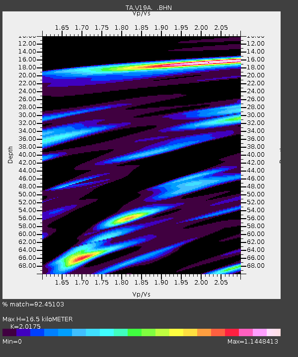
| Estimated Moho Depth: |
16.5 km |
| Estimated Crust Vp/Vs: |
2.02 |
| Assumed Crust Vp: |
6.496 km/s |
| Estimated Crust Vs: |
3.22 km/s |
| Estimated Crust Poisson's Ratio: |
0.34 |
|
| Radial Match: |
92.45103 % |
| Radial Bump: |
307 |
| Transverse Match: |
84.14488 % |
| Transverse Bump: |
396 |
| SOD ConfigId: |
2564 |
| Insert Time: |
2010-03-06 18:45:57.119 +0000 |
| GWidth: |
2.5 |
| Max Bumps: |
400 |
| Tol: |
0.001 |
|
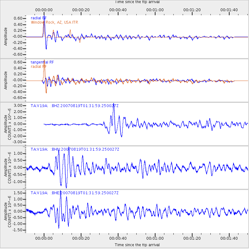
Signal To Noise
| Channel | StoN | STA | LTA |
| TA:V19A: :BHN:20070819T01:31:59.250027Z | 1.8147427 | 1.4742419E-7 | 8.123697E-8 |
| TA:V19A: :BHE:20070819T01:31:59.250027Z | 2.1621192 | 2.1558532E-7 | 9.971019E-8 |
| TA:V19A: :BHZ:20070819T01:31:59.250027Z | 7.079373 | 4.4562447E-7 | 6.294689E-8 |
| Arrivals |
| Ps | 2.7 SECOND |
| PpPs | 7.3 SECOND |
| PsPs/PpSs | 10 SECOND |


