You are here: Home > Network List > TS - TERRAscope (Southern California Seismic Network) Stations List
> Station BAR Barrett Dam, California, USA > Earthquake Result Viewer
BAR Barrett Dam, California, USA - Earthquake Result Viewer
*The percent match for this event was below the threshold and hence no stack was calculated.
| Earthquake location: |
Bismarck Sea |
| Earthquake latitude/longitude: |
-3.2/146.9 |
| Earthquake time(UTC): |
1996/11/23 (328) 10:35:45 GMT |
| Earthquake Depth: |
10 km |
| Earthquake Magnitude: |
5.6 MS, 5.1 MB, 5.9 UNKNOWN, 5.8 MW |
| Earthquake Catalog/Contributor: |
WHDF/NEIC |
|
| Network: |
TS TERRAscope (Southern California Seismic Network) |
| Station: |
BAR Barrett Dam, California, USA |
| Lat/Lon: |
32.68 N/116.67 W |
| Elevation: |
548 m |
|
| Distance: |
97.2 deg |
| Az: |
57.629 deg |
| Baz: |
270.755 deg |
| Ray Param: |
$rayparam |
*The percent match for this event was below the threshold and hence was not used in the summary stack. |
|
| Radial Match: |
77.16763 % |
| Radial Bump: |
400 |
| Transverse Match: |
57.68211 % |
| Transverse Bump: |
400 |
| SOD ConfigId: |
4480 |
| Insert Time: |
2010-02-26 14:02:09.081 +0000 |
| GWidth: |
2.5 |
| Max Bumps: |
400 |
| Tol: |
0.001 |
|
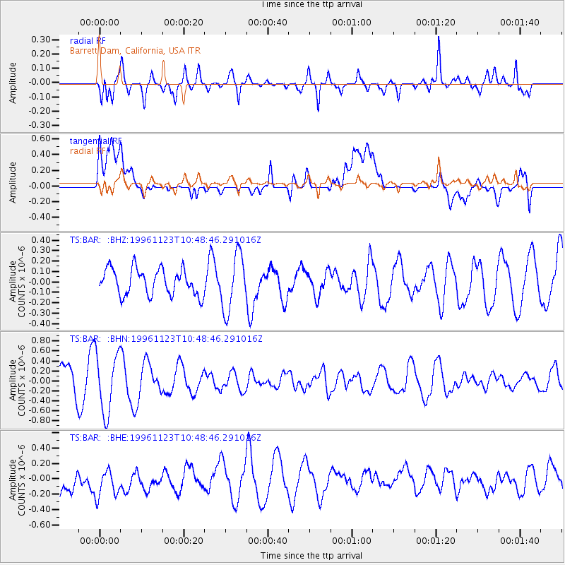
Signal To Noise
| Channel | StoN | STA | LTA |
| TS:BAR: :BHN:19961123T10:48:46.291016Z | 2.5693254 | 5.9026706E-7 | 2.2973619E-7 |
| TS:BAR: :BHE:19961123T10:48:46.291016Z | 0.9165739 | 3.5020847E-7 | 3.8208427E-7 |
| TS:BAR: :BHZ:19961123T10:48:46.291016Z | 2.2134426 | 2.7652825E-7 | 1.249313E-7 |
| Arrivals |
| Ps | |
| PpPs | |
| PsPs/PpSs | |


