You are here: Home > Network List > TA - USArray Transportable Network (new EarthScope stations) Stations List
> Station V19A Window Rock, AZ, USA > Earthquake Result Viewer
V19A Window Rock, AZ, USA - Earthquake Result Viewer
| Earthquake location: |
Sakhalin, Russia |
| Earthquake latitude/longitude: |
47.1/141.8 |
| Earthquake time(UTC): |
2007/08/02 (214) 02:37:42 GMT |
| Earthquake Depth: |
5.0 km |
| Earthquake Magnitude: |
6.2 MS, 5.3 MB, 6.2 MW, 6.2 MW |
| Earthquake Catalog/Contributor: |
WHDF/NEIC |
|
| Network: |
TA USArray Transportable Network (new EarthScope stations) |
| Station: |
V19A Window Rock, AZ, USA |
| Lat/Lon: |
35.71 N/109.05 W |
| Elevation: |
2082 m |
|
| Distance: |
76.0 deg |
| Az: |
52.401 deg |
| Baz: |
318.323 deg |
| Ray Param: |
0.05130709 |
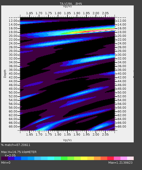
| Estimated Moho Depth: |
16.75 km |
| Estimated Crust Vp/Vs: |
2.05 |
| Assumed Crust Vp: |
6.496 km/s |
| Estimated Crust Vs: |
3.169 km/s |
| Estimated Crust Poisson's Ratio: |
0.34 |
|
| Radial Match: |
87.20611 % |
| Radial Bump: |
400 |
| Transverse Match: |
54.82976 % |
| Transverse Bump: |
400 |
| SOD ConfigId: |
2564 |
| Insert Time: |
2010-03-06 18:46:05.986 +0000 |
| GWidth: |
2.5 |
| Max Bumps: |
400 |
| Tol: |
0.001 |
|

Signal To Noise
| Channel | StoN | STA | LTA |
| TA:V19A: :BHN:20070802T02:48:58.999019Z | 1.3350756 | 1.1468881E-7 | 8.5904354E-8 |
| TA:V19A: :BHE:20070802T02:48:58.999019Z | 0.70308495 | 6.330052E-8 | 9.0032536E-8 |
| TA:V19A: :BHZ:20070802T02:48:58.999019Z | 1.6815033 | 9.525392E-8 | 5.664807E-8 |
| Arrivals |
| Ps | 2.8 SECOND |
| PpPs | 7.6 SECOND |
| PsPs/PpSs | 10 SECOND |


