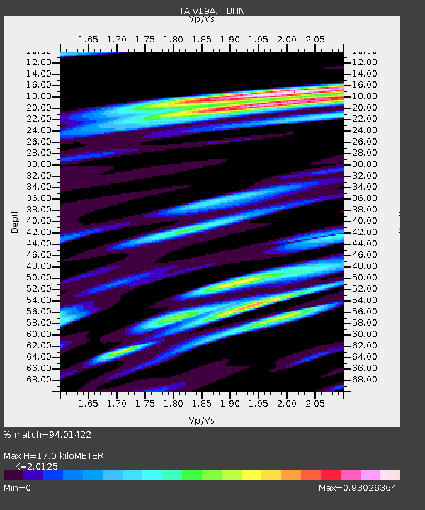
V19A Window Rock, AZ, USA - Earthquake Result Viewer
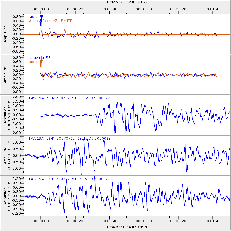
Earthquake location: Fox Islands, Aleutian Islands
Earthquake latitude/longitude: 52.5/-168.0
Earthquake time(UTC): 2007/07/15 (196) 13:08:00 GMT
Earthquake Depth: 10 km
Earthquake Magnitude: 5.8 MB, 5.9 MS, 6.1 MW, 6.0 MW
Earthquake Catalog/Contributor: WHDF/NEIC
Network: TA USArray Transportable Network (new EarthScope stations)
Station: V19A Window Rock, AZ, USA
Lat/Lon: 35.71 N/109.05 W
Elevation: 2082 m
Distance: 44.3 deg
Az: 88.04 deg
Baz: 311.311 deg
Ray Param: 0.07202345
Estimated Moho Depth: 17.0 km
Estimated Crust Vp/Vs: 2.01
Assumed Crust Vp: 6.496 km/s
Estimated Crust Vs: 3.228 km/s
Estimated Crust Poisson's Ratio: 0.34
Radial Match: 94.01422 %
Radial Bump: 327
Transverse Match: 84.48005 %
Transverse Bump: 400
SOD ConfigId: 2564
Insert Time: 2010-03-06 18:46:14.484 +0000
GWidth: 2.5
Max Bumps: 400
Tol: 0.001

Signal To Noise

ChannelStoNSTALTA
TA:V19A: :BHN:20070715T13:15:39.500002Z1.67852951.1809823E-77.035815E-8
TA:V19A: :BHE:20070715T13:15:39.500002Z2.3808381.5456021E-76.491841E-8
TA:V19A: :BHZ:20070715T13:15:39.500002Z4.12716053.0593444E-77.4127094E-8
Arrivals
Ps2.8 SECOND
PpPs7.4 SECOND
PsPs/PpSs10 SECOND