You are here: Home > Network List > AZ - ANZA Regional Network Stations List
> Station FRD AZ.FRD > Earthquake Result Viewer
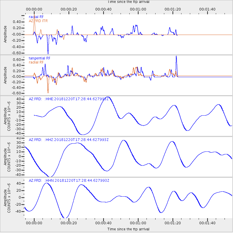
FRD AZ.FRD - Earthquake Result Viewer
*The percent match for this event was below the threshold and hence no stack was calculated.
| Earthquake location: |
Komandorskiye Ostrova Region |
| Earthquake latitude/longitude: |
55.1/164.9 |
| Earthquake time(UTC): |
2018/12/20 (354) 17:19:29 GMT |
| Earthquake Depth: |
10 km |
| Earthquake Magnitude: |
5.6 mb |
| Earthquake Catalog/Contributor: |
NEIC PDE/us |
|
| Network: |
AZ ANZA Regional Network |
| Station: |
FRD AZ.FRD |
| Lat/Lon: |
33.49 N/116.60 W |
| Elevation: |
1164 m |
|
| Distance: |
57.0 deg |
| Az: |
77.603 deg |
| Baz: |
317.758 deg |
| Ray Param: |
$rayparam |
*The percent match for this event was below the threshold and hence was not used in the summary stack. |
|
| Radial Match: |
80.76039 % |
| Radial Bump: |
301 |
| Transverse Match: |
51.062927 % |
| Transverse Bump: |
400 |
| SOD ConfigId: |
13570011 |
| Insert Time: |
2019-05-02 02:38:37.885 +0000 |
| GWidth: |
2.5 |
| Max Bumps: |
400 |
| Tol: |
0.001 |
|
Signal To Noise
| Channel | StoN | STA | LTA |
| AZ:FRD: :HHZ:20181220T17:28:44.627993Z | 2.086102 | 2.6046562E-5 | 1.2485757E-5 |
| AZ:FRD: :HHN:20181220T17:28:44.627993Z | 0.57784534 | 2.0664856E-5 | 3.5761917E-5 |
| AZ:FRD: :HHE:20181220T17:28:44.627993Z | 3.2368903 | 4.098731E-5 | 1.2662557E-5 |
| Arrivals |
| Ps | |
| PpPs | |
| PsPs/PpSs | |


