You are here: Home > Network List > TA - USArray Transportable Network (new EarthScope stations) Stations List
> Station V19A Window Rock, AZ, USA > Earthquake Result Viewer
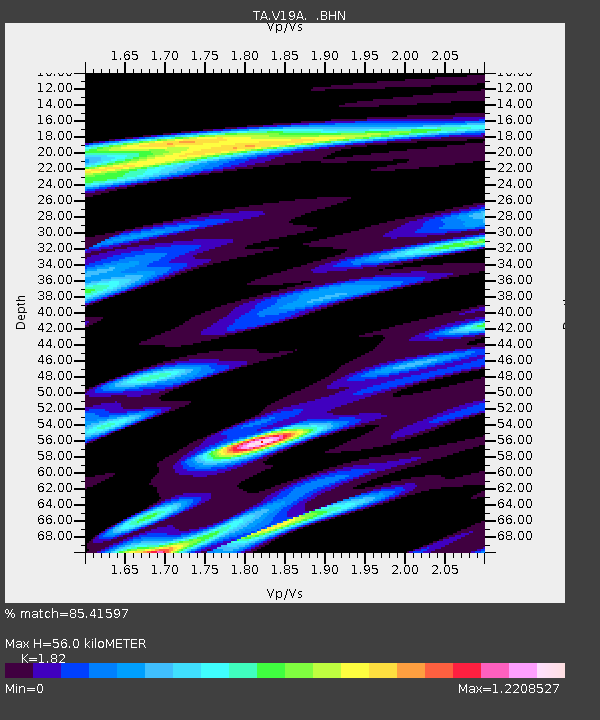
V19A Window Rock, AZ, USA - Earthquake Result Viewer
| Earthquake location: |
Peru-Brazil Border Region |
| Earthquake latitude/longitude: |
-7.9/-74.4 |
| Earthquake time(UTC): |
2007/07/12 (193) 05:23:49 GMT |
| Earthquake Depth: |
152 km |
| Earthquake Magnitude: |
5.9 MB, 6.1 MW, 6.0 MW |
| Earthquake Catalog/Contributor: |
WHDF/NEIC |
|
| Network: |
TA USArray Transportable Network (new EarthScope stations) |
| Station: |
V19A Window Rock, AZ, USA |
| Lat/Lon: |
35.71 N/109.05 W |
| Elevation: |
2082 m |
|
| Distance: |
54.3 deg |
| Az: |
325.258 deg |
| Baz: |
136.079 deg |
| Ray Param: |
0.065025516 |
| Estimated Moho Depth: |
56.0 km |
| Estimated Crust Vp/Vs: |
1.82 |
| Assumed Crust Vp: |
6.496 km/s |
| Estimated Crust Vs: |
3.569 km/s |
| Estimated Crust Poisson's Ratio: |
0.28 |
|
| Radial Match: |
85.41597 % |
| Radial Bump: |
400 |
| Transverse Match: |
79.57653 % |
| Transverse Bump: |
400 |
| SOD ConfigId: |
2564 |
| Insert Time: |
2010-03-06 18:46:18.772 +0000 |
| GWidth: |
2.5 |
| Max Bumps: |
400 |
| Tol: |
0.001 |
|

Signal To Noise
| Channel | StoN | STA | LTA |
| TA:V19A: :BHN:20070712T05:32:29.35001Z | 4.4604926 | 3.0059894E-7 | 6.739142E-8 |
| TA:V19A: :BHE:20070712T05:32:29.35001Z | 3.8205936 | 2.3483999E-7 | 6.1466885E-8 |
| TA:V19A: :BHZ:20070712T05:32:29.35001Z | 9.61806 | 6.287868E-7 | 6.537564E-8 |
| Arrivals |
| Ps | 7.4 SECOND |
| PpPs | 23 SECOND |
| PsPs/PpSs | 31 SECOND |


