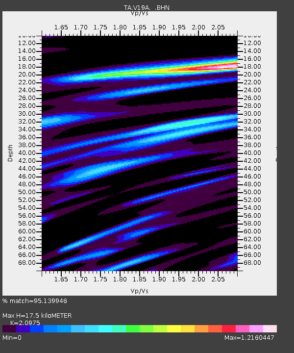
V19A Window Rock, AZ, USA - Earthquake Result Viewer
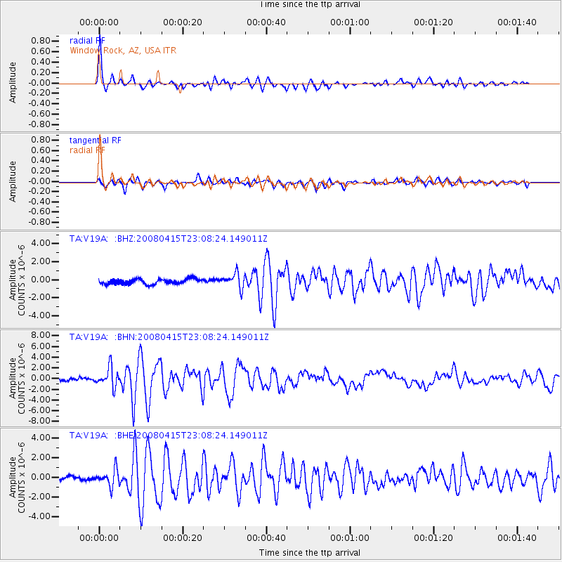
Earthquake location: Andreanof Islands, Aleutian Is.
Earthquake latitude/longitude: 51.9/-179.4
Earthquake time(UTC): 2008/04/15 (106) 22:59:51 GMT
Earthquake Depth: 10 km
Earthquake Magnitude: 6.1 MB, 6.4 MS, 6.4 MW, 6.4 MW
Earthquake Catalog/Contributor: WHDF/NEIC
Network: TA USArray Transportable Network (new EarthScope stations)
Station: V19A Window Rock, AZ, USA
Lat/Lon: 35.71 N/109.05 W
Elevation: 2082 m
Distance: 51.3 deg
Az: 79.255 deg
Baz: 311.514 deg
Ray Param: 0.06753161
Estimated Moho Depth: 17.5 km
Estimated Crust Vp/Vs: 2.10
Assumed Crust Vp: 6.496 km/s
Estimated Crust Vs: 3.097 km/s
Estimated Crust Poisson's Ratio: 0.35
Radial Match: 95.139946 %
Radial Bump: 357
Transverse Match: 88.04623 %
Transverse Bump: 400
SOD ConfigId: 2504
Insert Time: 2010-03-06 18:46:22.616 +0000
GWidth: 2.5
Max Bumps: 400
Tol: 0.001

Signal To Noise

ChannelStoNSTALTA
TA:V19A: :BHN:20080415T23:08:24.149011Z7.6530491.8379774E-62.4016276E-7
TA:V19A: :BHE:20080415T23:08:24.149011Z3.47866498.4461544E-72.4279873E-7
TA:V19A: :BHZ:20080415T23:08:24.149011Z2.94167338.3825216E-72.849576E-7
Arrivals
Ps3.1 SECOND
PpPs7.9 SECOND
PsPs/PpSs11 SECOND