You are here: Home > Network List > TA - USArray Transportable Network (new EarthScope stations) Stations List
> Station V19A Window Rock, AZ, USA > Earthquake Result Viewer
V19A Window Rock, AZ, USA - Earthquake Result Viewer
| Earthquake location: |
Tonga Islands |
| Earthquake latitude/longitude: |
-20.8/-173.3 |
| Earthquake time(UTC): |
2008/06/26 (178) 21:19:15 GMT |
| Earthquake Depth: |
38 km |
| Earthquake Magnitude: |
6.0 MB, 5.8 MS, 6.2 MW, 6.1 MW |
| Earthquake Catalog/Contributor: |
WHDF/NEIC |
|
| Network: |
TA USArray Transportable Network (new EarthScope stations) |
| Station: |
V19A Window Rock, AZ, USA |
| Lat/Lon: |
35.71 N/109.05 W |
| Elevation: |
2082 m |
|
| Distance: |
82.8 deg |
| Az: |
47.655 deg |
| Baz: |
238.203 deg |
| Ray Param: |
0.04658437 |
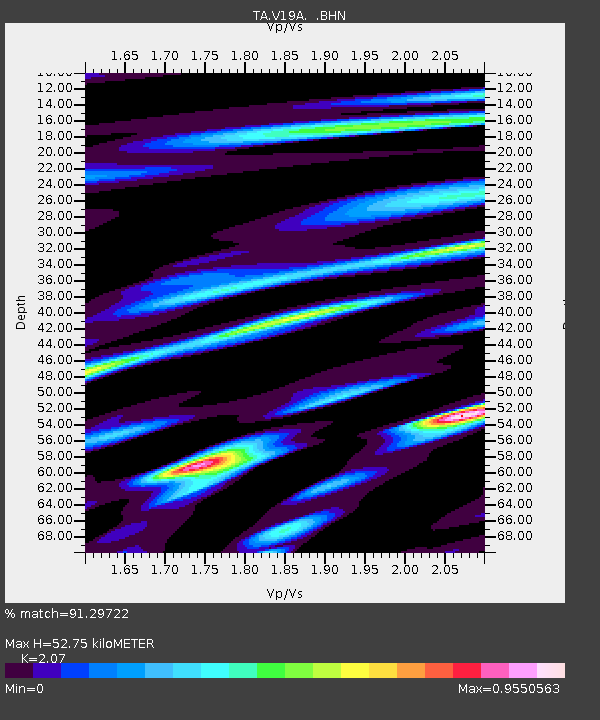
| Estimated Moho Depth: |
52.75 km |
| Estimated Crust Vp/Vs: |
2.07 |
| Assumed Crust Vp: |
6.496 km/s |
| Estimated Crust Vs: |
3.138 km/s |
| Estimated Crust Poisson's Ratio: |
0.35 |
|
| Radial Match: |
91.29722 % |
| Radial Bump: |
400 |
| Transverse Match: |
79.076706 % |
| Transverse Bump: |
400 |
| SOD ConfigId: |
2504 |
| Insert Time: |
2010-03-06 18:46:31.176 +0000 |
| GWidth: |
2.5 |
| Max Bumps: |
400 |
| Tol: |
0.001 |
|
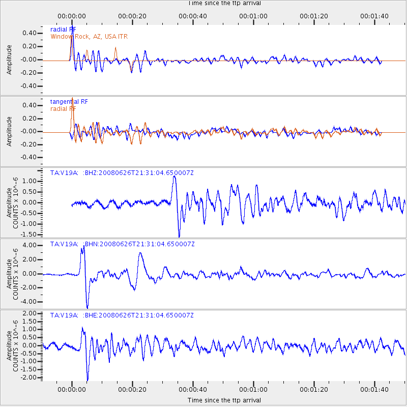
Signal To Noise
| Channel | StoN | STA | LTA |
| TA:V19A: :BHN:20080626T21:31:04.650007Z | 31.631927 | 1.8530031E-6 | 5.8580156E-8 |
| TA:V19A: :BHE:20080626T21:31:04.650007Z | 5.1147914 | 4.7272488E-7 | 9.24231E-8 |
| TA:V19A: :BHZ:20080626T21:31:04.650007Z | 5.533452 | 5.7208393E-7 | 1.0338644E-7 |
| Arrivals |
| Ps | 8.9 SECOND |
| PpPs | 24 SECOND |
| PsPs/PpSs | 33 SECOND |


