You are here: Home > Network List > TA - USArray Transportable Network (new EarthScope stations) Stations List
> Station V19A Window Rock, AZ, USA > Earthquake Result Viewer
V19A Window Rock, AZ, USA - Earthquake Result Viewer
| Earthquake location: |
Sea Of Okhotsk |
| Earthquake latitude/longitude: |
53.9/152.9 |
| Earthquake time(UTC): |
2008/07/05 (187) 02:12:04 GMT |
| Earthquake Depth: |
633 km |
| Earthquake Magnitude: |
6.8 MB, 7.7 MW, 7.7 MW |
| Earthquake Catalog/Contributor: |
WHDF/NEIC |
|
| Network: |
TA USArray Transportable Network (new EarthScope stations) |
| Station: |
V19A Window Rock, AZ, USA |
| Lat/Lon: |
35.71 N/109.05 W |
| Elevation: |
2082 m |
|
| Distance: |
66.4 deg |
| Az: |
61.575 deg |
| Baz: |
320.223 deg |
| Ray Param: |
0.055292647 |
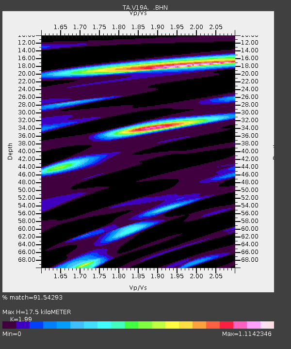
| Estimated Moho Depth: |
17.5 km |
| Estimated Crust Vp/Vs: |
1.99 |
| Assumed Crust Vp: |
6.496 km/s |
| Estimated Crust Vs: |
3.264 km/s |
| Estimated Crust Poisson's Ratio: |
0.33 |
|
| Radial Match: |
91.54293 % |
| Radial Bump: |
400 |
| Transverse Match: |
88.136375 % |
| Transverse Bump: |
400 |
| SOD ConfigId: |
2504 |
| Insert Time: |
2010-03-06 18:46:32.608 +0000 |
| GWidth: |
2.5 |
| Max Bumps: |
400 |
| Tol: |
0.001 |
|
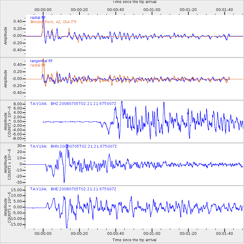
Signal To Noise
| Channel | StoN | STA | LTA |
| TA:V19A: :BHN:20080705T02:21:21.675007Z | 34.43061 | 3.739508E-6 | 1.0860998E-7 |
| TA:V19A: :BHE:20080705T02:21:21.675007Z | 16.506205 | 1.6335978E-6 | 9.896871E-8 |
| TA:V19A: :BHZ:20080705T02:21:21.675007Z | 11.538463 | 9.688208E-7 | 8.396446E-8 |
| Arrivals |
| Ps | 2.8 SECOND |
| PpPs | 7.8 SECOND |
| PsPs/PpSs | 11 SECOND |


