You are here: Home > Network List > LD - Lamont-Doherty Cooperative Seismographic Network Stations List
> Station GEDE Greenville, DE, USA > Earthquake Result Viewer
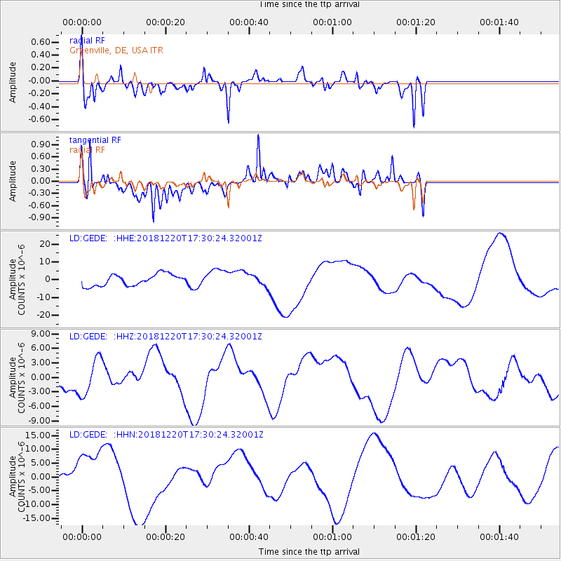
GEDE Greenville, DE, USA - Earthquake Result Viewer
*The percent match for this event was below the threshold and hence no stack was calculated.
| Earthquake location: |
Komandorskiye Ostrova Region |
| Earthquake latitude/longitude: |
55.1/164.9 |
| Earthquake time(UTC): |
2018/12/20 (354) 17:19:29 GMT |
| Earthquake Depth: |
10 km |
| Earthquake Magnitude: |
5.6 mb |
| Earthquake Catalog/Contributor: |
NEIC PDE/us |
|
| Network: |
LD Lamont-Doherty Cooperative Seismographic Network |
| Station: |
GEDE Greenville, DE, USA |
| Lat/Lon: |
39.81 N/75.64 W |
| Elevation: |
105 m |
|
| Distance: |
72.3 deg |
| Az: |
44.718 deg |
| Baz: |
328.304 deg |
| Ray Param: |
$rayparam |
*The percent match for this event was below the threshold and hence was not used in the summary stack. |
|
| Radial Match: |
72.545334 % |
| Radial Bump: |
377 |
| Transverse Match: |
74.19341 % |
| Transverse Bump: |
400 |
| SOD ConfigId: |
13570011 |
| Insert Time: |
2019-05-02 02:41:52.004 +0000 |
| GWidth: |
2.5 |
| Max Bumps: |
400 |
| Tol: |
0.001 |
|
Signal To Noise
| Channel | StoN | STA | LTA |
| LD:GEDE: :HHZ:20181220T17:30:24.32001Z | 2.329615 | 3.8110877E-6 | 1.6359303E-6 |
| LD:GEDE: :HHN:20181220T17:30:24.32001Z | 2.605093 | 8.737923E-6 | 3.3541694E-6 |
| LD:GEDE: :HHE:20181220T17:30:24.32001Z | 1.6067337 | 5.1389657E-6 | 3.198393E-6 |
| Arrivals |
| Ps | |
| PpPs | |
| PsPs/PpSs | |


