You are here: Home > Network List > TA - USArray Transportable Network (new EarthScope stations) Stations List
> Station V19A Window Rock, AZ, USA > Earthquake Result Viewer
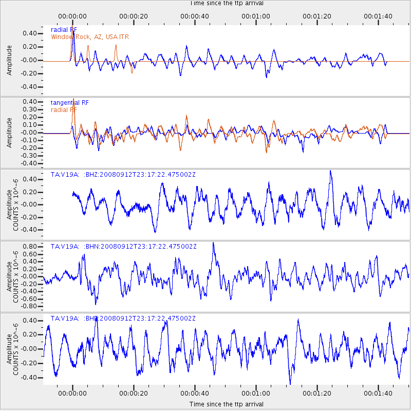
V19A Window Rock, AZ, USA - Earthquake Result Viewer
*The percent match for this event was below the threshold and hence no stack was calculated.
| Earthquake location: |
Komandorskiye Ostrova Region |
| Earthquake latitude/longitude: |
56.3/164.1 |
| Earthquake time(UTC): |
2008/09/12 (256) 23:07:50 GMT |
| Earthquake Depth: |
9.3 km |
| Earthquake Magnitude: |
5.5 MB, 5.7 MS, 5.9 MW, 5.9 MW |
| Earthquake Catalog/Contributor: |
WHDF/NEIC |
|
| Network: |
TA USArray Transportable Network (new EarthScope stations) |
| Station: |
V19A Window Rock, AZ, USA |
| Lat/Lon: |
35.71 N/109.05 W |
| Elevation: |
2082 m |
|
| Distance: |
59.5 deg |
| Az: |
70.549 deg |
| Baz: |
319.776 deg |
| Ray Param: |
$rayparam |
*The percent match for this event was below the threshold and hence was not used in the summary stack. |
|
| Radial Match: |
62.15138 % |
| Radial Bump: |
400 |
| Transverse Match: |
58.68205 % |
| Transverse Bump: |
400 |
| SOD ConfigId: |
2560 |
| Insert Time: |
2010-03-06 18:47:00.150 +0000 |
| GWidth: |
2.5 |
| Max Bumps: |
400 |
| Tol: |
0.001 |
|
Signal To Noise
| Channel | StoN | STA | LTA |
| TA:V19A: :BHN:20080912T23:17:22.475002Z | 1.6827124 | 2.5180725E-7 | 1.4964365E-7 |
| TA:V19A: :BHE:20080912T23:17:22.475002Z | 0.7838172 | 1.3738267E-7 | 1.7527387E-7 |
| TA:V19A: :BHZ:20080912T23:17:22.475002Z | 1.4630433 | 1.7899984E-7 | 1.223476E-7 |
| Arrivals |
| Ps | |
| PpPs | |
| PsPs/PpSs | |


