You are here: Home > Network List > TA - USArray Transportable Network (new EarthScope stations) Stations List
> Station V19A Window Rock, AZ, USA > Earthquake Result Viewer
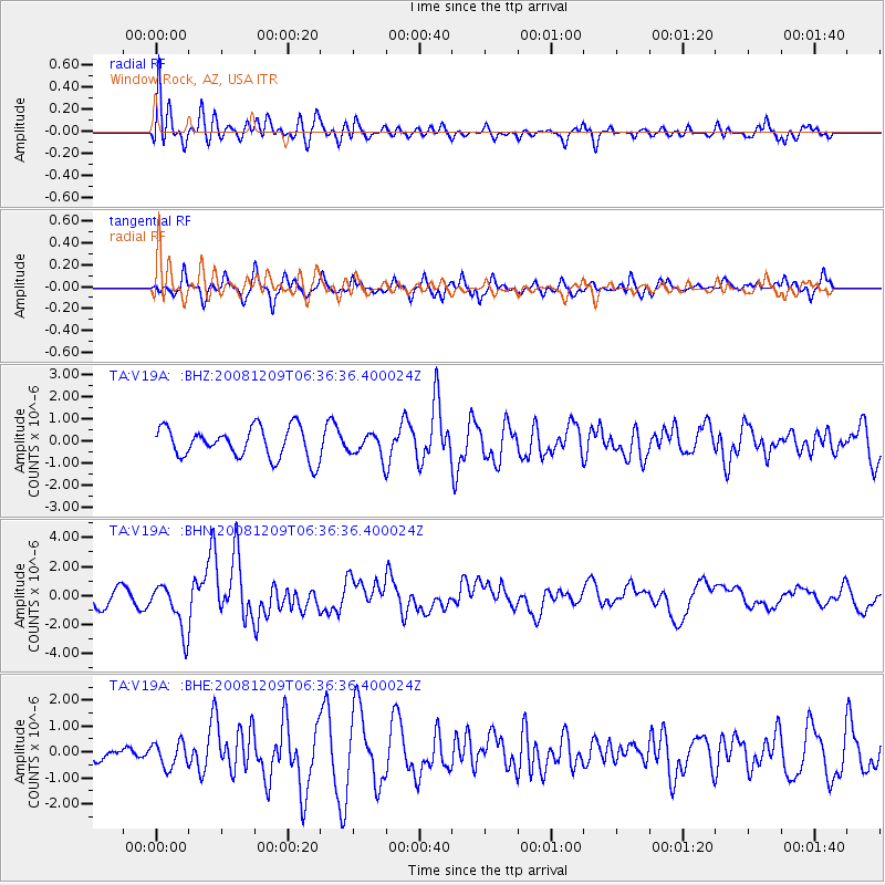
V19A Window Rock, AZ, USA - Earthquake Result Viewer
*The percent match for this event was below the threshold and hence no stack was calculated.
| Earthquake location: |
Kermadec Islands Region |
| Earthquake latitude/longitude: |
-31.2/-176.9 |
| Earthquake time(UTC): |
2008/12/09 (344) 06:23:59 GMT |
| Earthquake Depth: |
18 km |
| Earthquake Magnitude: |
6.2 MB, 6.7 MS, 6.8 MW, 6.7 MW |
| Earthquake Catalog/Contributor: |
WHDF/NEIC |
|
| Network: |
TA USArray Transportable Network (new EarthScope stations) |
| Station: |
V19A Window Rock, AZ, USA |
| Lat/Lon: |
35.71 N/109.05 W |
| Elevation: |
2082 m |
|
| Distance: |
92.1 deg |
| Az: |
48.974 deg |
| Baz: |
232.571 deg |
| Ray Param: |
$rayparam |
*The percent match for this event was below the threshold and hence was not used in the summary stack. |
|
| Radial Match: |
74.542145 % |
| Radial Bump: |
400 |
| Transverse Match: |
63.0477 % |
| Transverse Bump: |
369 |
| SOD ConfigId: |
2658 |
| Insert Time: |
2010-03-06 18:47:04.608 +0000 |
| GWidth: |
2.5 |
| Max Bumps: |
400 |
| Tol: |
0.001 |
|
Signal To Noise
| Channel | StoN | STA | LTA |
| TA:V19A: :BHN:20081209T06:36:36.400024Z | 2.179449 | 1.660897E-6 | 7.620719E-7 |
| TA:V19A: :BHE:20081209T06:36:36.400024Z | 0.6700017 | 4.8441154E-7 | 7.230005E-7 |
| TA:V19A: :BHZ:20081209T06:36:36.400024Z | 0.76850146 | 5.3132317E-7 | 6.9137565E-7 |
| Arrivals |
| Ps | |
| PpPs | |
| PsPs/PpSs | |


