You are here: Home > Network List > TA - USArray Transportable Network (new EarthScope stations) Stations List
> Station V19A Window Rock, AZ, USA > Earthquake Result Viewer
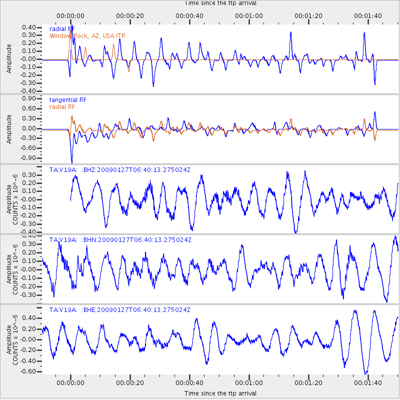
V19A Window Rock, AZ, USA - Earthquake Result Viewer
*The percent match for this event was below the threshold and hence no stack was calculated.
| Earthquake location: |
Fiji Islands Region |
| Earthquake latitude/longitude: |
-17.8/-178.7 |
| Earthquake time(UTC): |
2009/01/27 (027) 06:29:13 GMT |
| Earthquake Depth: |
601 km |
| Earthquake Magnitude: |
5.9 MW, 5.1 MB, 5.8 MW |
| Earthquake Catalog/Contributor: |
WHDF/NEIC |
|
| Network: |
TA USArray Transportable Network (new EarthScope stations) |
| Station: |
V19A Window Rock, AZ, USA |
| Lat/Lon: |
35.71 N/109.05 W |
| Elevation: |
2082 m |
|
| Distance: |
84.7 deg |
| Az: |
50.015 deg |
| Baz: |
243.746 deg |
| Ray Param: |
$rayparam |
*The percent match for this event was below the threshold and hence was not used in the summary stack. |
|
| Radial Match: |
57.597187 % |
| Radial Bump: |
400 |
| Transverse Match: |
68.785446 % |
| Transverse Bump: |
400 |
| SOD ConfigId: |
2658 |
| Insert Time: |
2010-03-06 18:47:10.116 +0000 |
| GWidth: |
2.5 |
| Max Bumps: |
400 |
| Tol: |
0.001 |
|
Signal To Noise
| Channel | StoN | STA | LTA |
| TA:V19A: :BHN:20090127T06:40:13.275024Z | 0.5448097 | 1.10773E-7 | 2.033242E-7 |
| TA:V19A: :BHE:20090127T06:40:13.275024Z | 0.8610637 | 1.673002E-7 | 1.942948E-7 |
| TA:V19A: :BHZ:20090127T06:40:13.275024Z | 1.2142869 | 1.6985034E-7 | 1.398766E-7 |
| Arrivals |
| Ps | |
| PpPs | |
| PsPs/PpSs | |


