You are here: Home > Network List > TA - USArray Transportable Network (new EarthScope stations) Stations List
> Station R11B Troy Canyon, Currant, NV, USA > Earthquake Result Viewer
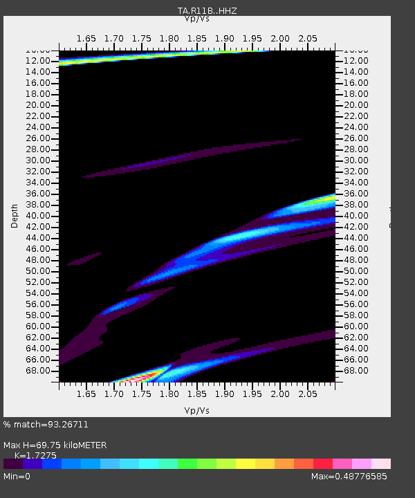
R11B Troy Canyon, Currant, NV, USA - Earthquake Result Viewer
| Earthquake location: |
Komandorskiye Ostrova Region |
| Earthquake latitude/longitude: |
55.1/164.9 |
| Earthquake time(UTC): |
2018/12/20 (354) 17:19:29 GMT |
| Earthquake Depth: |
10 km |
| Earthquake Magnitude: |
5.6 mb |
| Earthquake Catalog/Contributor: |
NEIC PDE/us |
|
| Network: |
TA USArray Transportable Network (new EarthScope stations) |
| Station: |
R11B Troy Canyon, Currant, NV, USA |
| Lat/Lon: |
38.35 N/115.59 W |
| Elevation: |
1767 m |
|
| Distance: |
54.0 deg |
| Az: |
72.843 deg |
| Baz: |
315.655 deg |
| Ray Param: |
0.06570918 |
| Estimated Moho Depth: |
69.75 km |
| Estimated Crust Vp/Vs: |
1.73 |
| Assumed Crust Vp: |
6.276 km/s |
| Estimated Crust Vs: |
3.633 km/s |
| Estimated Crust Poisson's Ratio: |
0.25 |
|
| Radial Match: |
93.26711 % |
| Radial Bump: |
312 |
| Transverse Match: |
56.56183 % |
| Transverse Bump: |
303 |
| SOD ConfigId: |
13570011 |
| Insert Time: |
2019-05-02 02:45:40.738 +0000 |
| GWidth: |
2.5 |
| Max Bumps: |
400 |
| Tol: |
0.001 |
|

Signal To Noise
| Channel | StoN | STA | LTA |
| TA:R11B: :HHZ:20181220T17:28:23.340029Z | 1.4407437 | 4.2602944E-5 | 2.9570108E-5 |
| TA:R11B: :HHN:20181220T17:28:23.340029Z | 1.5167884 | 3.4701123E-5 | 2.2878025E-5 |
| TA:R11B: :HHE:20181220T17:28:23.340029Z | 0.67309606 | 1.5163897E-5 | 2.2528578E-5 |
| Arrivals |
| Ps | 8.5 SECOND |
| PpPs | 29 SECOND |
| PsPs/PpSs | 37 SECOND |


