You are here: Home > Network List > AZ - ANZA Regional Network Stations List
> Station SMER AZ.SMER > Earthquake Result Viewer
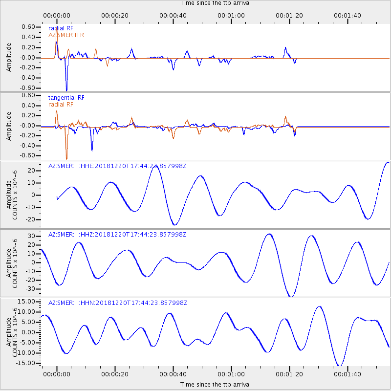
SMER AZ.SMER - Earthquake Result Viewer
*The percent match for this event was below the threshold and hence no stack was calculated.
| Earthquake location: |
Komandorskiye Ostrova Region |
| Earthquake latitude/longitude: |
54.9/164.7 |
| Earthquake time(UTC): |
2018/12/20 (354) 17:35:10 GMT |
| Earthquake Depth: |
10 km |
| Earthquake Magnitude: |
5.6 mb |
| Earthquake Catalog/Contributor: |
NEIC PDE/us |
|
| Network: |
AZ ANZA Regional Network |
| Station: |
SMER AZ.SMER |
| Lat/Lon: |
33.46 N/117.17 W |
| Elevation: |
355 m |
|
| Distance: |
56.8 deg |
| Az: |
77.786 deg |
| Baz: |
317.479 deg |
| Ray Param: |
$rayparam |
*The percent match for this event was below the threshold and hence was not used in the summary stack. |
|
| Radial Match: |
93.72142 % |
| Radial Bump: |
347 |
| Transverse Match: |
65.033455 % |
| Transverse Bump: |
400 |
| SOD ConfigId: |
13570011 |
| Insert Time: |
2019-05-02 02:48:05.748 +0000 |
| GWidth: |
2.5 |
| Max Bumps: |
400 |
| Tol: |
0.001 |
|
Signal To Noise
| Channel | StoN | STA | LTA |
| AZ:SMER: :HHZ:20181220T17:44:23.857998Z | 1.4598551 | 1.9473862E-5 | 1.3339586E-5 |
| AZ:SMER: :HHN:20181220T17:44:23.857998Z | 1.0519587 | 7.608672E-6 | 7.232862E-6 |
| AZ:SMER: :HHE:20181220T17:44:23.857998Z | 2.4107153 | 1.6386783E-5 | 6.797477E-6 |
| Arrivals |
| Ps | |
| PpPs | |
| PsPs/PpSs | |


