You are here: Home > Network List > CA - Catalan Seismic Network Stations List
> Station EBR Ebre > Earthquake Result Viewer
EBR Ebre - Earthquake Result Viewer
| Earthquake location: |
Komandorskiye Ostrova Region |
| Earthquake latitude/longitude: |
54.9/164.7 |
| Earthquake time(UTC): |
2018/12/20 (354) 17:35:10 GMT |
| Earthquake Depth: |
10 km |
| Earthquake Magnitude: |
5.6 mb |
| Earthquake Catalog/Contributor: |
NEIC PDE/us |
|
| Network: |
CA Catalan Seismic Network |
| Station: |
EBR Ebre |
| Lat/Lon: |
40.82 N/0.49 E |
| Elevation: |
36 m |
|
| Distance: |
83.7 deg |
| Az: |
347.993 deg |
| Baz: |
9.117 deg |
| Ray Param: |
0.045979664 |
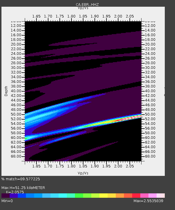
| Estimated Moho Depth: |
51.25 km |
| Estimated Crust Vp/Vs: |
2.06 |
| Assumed Crust Vp: |
6.391 km/s |
| Estimated Crust Vs: |
3.106 km/s |
| Estimated Crust Poisson's Ratio: |
0.35 |
|
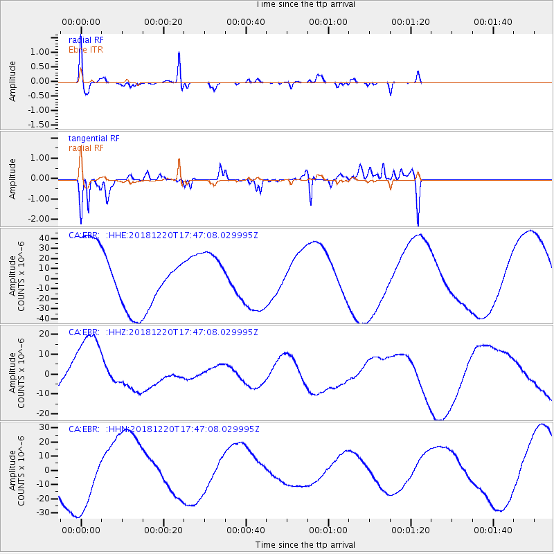
| Radial Match: |
89.577225 % |
| Radial Bump: |
315 |
| Transverse Match: |
84.26373 % |
| Transverse Bump: |
271 |
| SOD ConfigId: |
13570011 |
| Insert Time: |
2019-05-02 02:48:24.158 +0000 |
| GWidth: |
2.5 |
| Max Bumps: |
400 |
| Tol: |
0.001 |
|
Signal To Noise
| Channel | StoN | STA | LTA |
| CA:EBR: :HHZ:20181220T17:47:08.029995Z | 3.042693 | 1.9753157E-5 | 6.4919986E-6 |
| CA:EBR: :HHN:20181220T17:47:08.029995Z | 1.8760115 | 2.425966E-5 | 1.2931509E-5 |
| CA:EBR: :HHE:20181220T17:47:08.029995Z | 0.8170583 | 2.3670536E-5 | 2.8970435E-5 |
| Arrivals |
| Ps | 8.7 SECOND |
| PpPs | 24 SECOND |
| PsPs/PpSs | 33 SECOND |


