You are here: Home > Network List > CI - Caltech Regional Seismic Network Stations List
> Station MPM Manuel Prospect Mine, California, USA > Earthquake Result Viewer
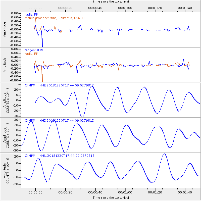
MPM Manuel Prospect Mine, California, USA - Earthquake Result Viewer
*The percent match for this event was below the threshold and hence no stack was calculated.
| Earthquake location: |
Komandorskiye Ostrova Region |
| Earthquake latitude/longitude: |
54.9/164.7 |
| Earthquake time(UTC): |
2018/12/20 (354) 17:35:10 GMT |
| Earthquake Depth: |
10 km |
| Earthquake Magnitude: |
5.6 mb |
| Earthquake Catalog/Contributor: |
NEIC PDE/us |
|
| Network: |
CI Caltech Regional Seismic Network |
| Station: |
MPM Manuel Prospect Mine, California, USA |
| Lat/Lon: |
36.06 N/117.49 W |
| Elevation: |
185 m |
|
| Distance: |
54.8 deg |
| Az: |
75.872 deg |
| Baz: |
316.223 deg |
| Ray Param: |
$rayparam |
*The percent match for this event was below the threshold and hence was not used in the summary stack. |
|
| Radial Match: |
92.50336 % |
| Radial Bump: |
274 |
| Transverse Match: |
70.84547 % |
| Transverse Bump: |
400 |
| SOD ConfigId: |
13570011 |
| Insert Time: |
2019-05-02 02:48:49.052 +0000 |
| GWidth: |
2.5 |
| Max Bumps: |
400 |
| Tol: |
0.001 |
|
Signal To Noise
| Channel | StoN | STA | LTA |
| CI:MPM: :HHZ:20181220T17:44:09.027981Z | 1.4257796 | 1.9214056E-5 | 1.3476175E-5 |
| CI:MPM: :HHN:20181220T17:44:09.027981Z | 0.94697446 | 1.3784187E-5 | 1.4556029E-5 |
| CI:MPM: :HHE:20181220T17:44:09.027981Z | 4.4275794 | 2.4530847E-5 | 5.540465E-6 |
| Arrivals |
| Ps | |
| PpPs | |
| PsPs/PpSs | |


