You are here: Home > Network List > IW - Intermountain West Stations List
> Station MOOW Moose Ponds, Wyoming, USA > Earthquake Result Viewer
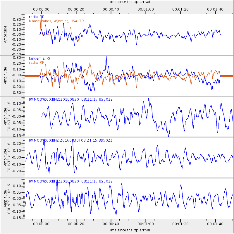
MOOW Moose Ponds, Wyoming, USA - Earthquake Result Viewer
*The percent match for this event was below the threshold and hence no stack was calculated.
| Earthquake location: |
Near Coast Of Central Chile |
| Earthquake latitude/longitude: |
-34.9/-72.5 |
| Earthquake time(UTC): |
2016/08/30 (243) 08:09:10 GMT |
| Earthquake Depth: |
19 km |
| Earthquake Magnitude: |
5.5 MB, 5.5 MB |
| Earthquake Catalog/Contributor: |
NEIC PDE/NEIC ALERT |
|
| Network: |
IW Intermountain West |
| Station: |
MOOW Moose Ponds, Wyoming, USA |
| Lat/Lon: |
43.75 N/110.74 W |
| Elevation: |
2128 m |
|
| Distance: |
85.7 deg |
| Az: |
333.282 deg |
| Baz: |
149.34 deg |
| Ray Param: |
$rayparam |
*The percent match for this event was below the threshold and hence was not used in the summary stack. |
|
| Radial Match: |
62.905964 % |
| Radial Bump: |
400 |
| Transverse Match: |
57.008724 % |
| Transverse Bump: |
400 |
| SOD ConfigId: |
1634031 |
| Insert Time: |
2016-09-13 08:12:34.894 +0000 |
| GWidth: |
2.5 |
| Max Bumps: |
400 |
| Tol: |
0.001 |
|
Signal To Noise
| Channel | StoN | STA | LTA |
| IW:MOOW:00:BHZ:20160830T08:21:15.89502Z | 2.5792196 | 1.4781891E-7 | 5.731149E-8 |
| IW:MOOW:00:BH1:20160830T08:21:15.89502Z | 0.29151708 | 1.9099321E-8 | 6.551699E-8 |
| IW:MOOW:00:BH2:20160830T08:21:15.89502Z | 0.8212437 | 4.1716937E-8 | 5.079727E-8 |
| Arrivals |
| Ps | |
| PpPs | |
| PsPs/PpSs | |


