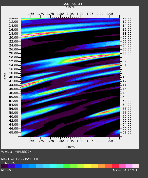
N17A Moffit Pass, UT, USA - Earthquake Result Viewer
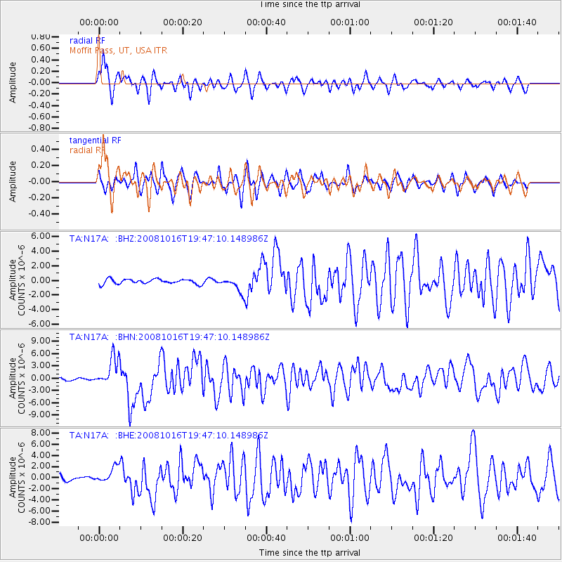
Earthquake location: Near Coast Of Chiapas, Mexico
Earthquake latitude/longitude: 14.4/-92.4
Earthquake time(UTC): 2008/10/16 (290) 19:41:25 GMT
Earthquake Depth: 24 km
Earthquake Magnitude: 6.1 MB, 6.6 MS, 6.7 MW, 6.6 MW
Earthquake Catalog/Contributor: WHDF/NEIC
Network: TA USArray Transportable Network (new EarthScope stations)
Station: N17A Moffit Pass, UT, USA
Lat/Lon: 40.94 N/110.83 W
Elevation: 2500 m
Distance: 30.9 deg
Az: 332.172 deg
Baz: 143.34 deg
Ray Param: 0.07918313
Estimated Moho Depth: 18.75 km
Estimated Crust Vp/Vs: 1.63
Assumed Crust Vp: 6.155 km/s
Estimated Crust Vs: 3.776 km/s
Estimated Crust Poisson's Ratio: 0.20
Radial Match: 84.58114 %
Radial Bump: 400
Transverse Match: 80.25325 %
Transverse Bump: 400
SOD ConfigId: 2556
Insert Time: 2010-03-06 18:47:54.962 +0000
GWidth: 2.5
Max Bumps: 400
Tol: 0.001

Signal To Noise

ChannelStoNSTALTA
TA:N17A: :BHN:20081016T19:47:10.148986Z15.9162093.7355792E-62.3470282E-7
TA:N17A: :BHE:20081016T19:47:10.148986Z2.82243681.4388404E-65.097866E-7
TA:N17A: :BHZ:20081016T19:47:10.148986Z3.32972171.0873065E-63.2654575E-7
Arrivals
Ps2.1 SECOND
PpPs7.4 SECOND
PsPs/PpSs9.5 SECOND