You are here: Home > Network List > TA - USArray Transportable Network (new EarthScope stations) Stations List
> Station N17A Moffit Pass, UT, USA > Earthquake Result Viewer
N17A Moffit Pass, UT, USA - Earthquake Result Viewer
| Earthquake location: |
Vanuatu Islands |
| Earthquake latitude/longitude: |
-14.8/168.0 |
| Earthquake time(UTC): |
2008/11/07 (312) 07:19:35 GMT |
| Earthquake Depth: |
13 km |
| Earthquake Magnitude: |
6.0 MB, 6.3 MS, 6.4 MW, 6.4 MW |
| Earthquake Catalog/Contributor: |
WHDF/NEIC |
|
| Network: |
TA USArray Transportable Network (new EarthScope stations) |
| Station: |
N17A Moffit Pass, UT, USA |
| Lat/Lon: |
40.94 N/110.83 W |
| Elevation: |
2500 m |
|
| Distance: |
93.0 deg |
| Az: |
48.551 deg |
| Baz: |
253.12 deg |
| Ray Param: |
0.04133717 |
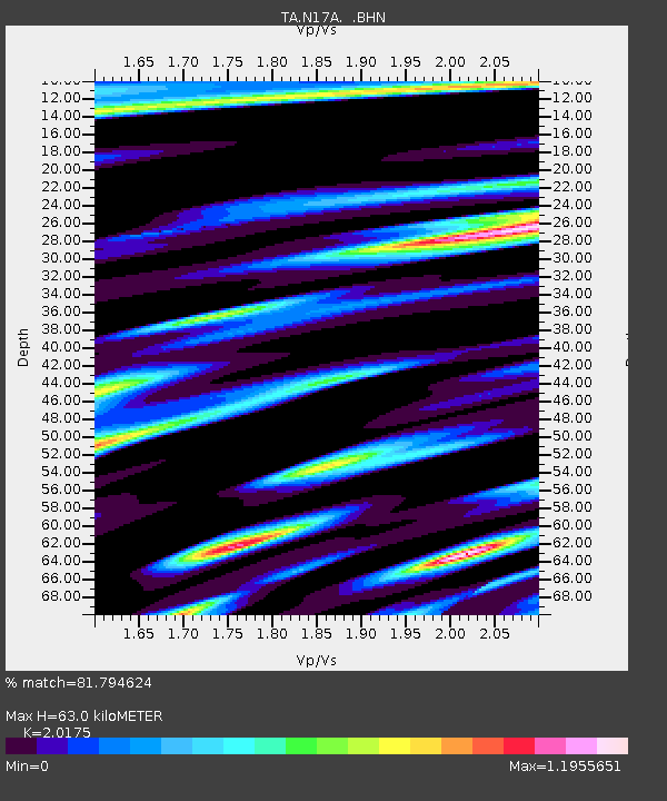
| Estimated Moho Depth: |
63.0 km |
| Estimated Crust Vp/Vs: |
2.02 |
| Assumed Crust Vp: |
6.155 km/s |
| Estimated Crust Vs: |
3.051 km/s |
| Estimated Crust Poisson's Ratio: |
0.34 |
|
| Radial Match: |
81.794624 % |
| Radial Bump: |
353 |
| Transverse Match: |
53.979713 % |
| Transverse Bump: |
341 |
| SOD ConfigId: |
2658 |
| Insert Time: |
2010-03-06 18:47:58.040 +0000 |
| GWidth: |
2.5 |
| Max Bumps: |
400 |
| Tol: |
0.001 |
|

Signal To Noise
| Channel | StoN | STA | LTA |
| TA:N17A: :BHN:20081107T07:32:17.275002Z | 2.6630998 | 4.838322E-7 | 1.8168008E-7 |
| TA:N17A: :BHE:20081107T07:32:17.275002Z | 1.844135 | 5.1401435E-7 | 2.7872923E-7 |
| TA:N17A: :BHZ:20081107T07:32:17.275002Z | 1.4028451 | 3.6580408E-7 | 2.607587E-7 |
| Arrivals |
| Ps | 11 SECOND |
| PpPs | 30 SECOND |
| PsPs/PpSs | 41 SECOND |


