You are here: Home > Network List > TA - USArray Transportable Network (new EarthScope stations) Stations List
> Station N17A Moffit Pass, UT, USA > Earthquake Result Viewer
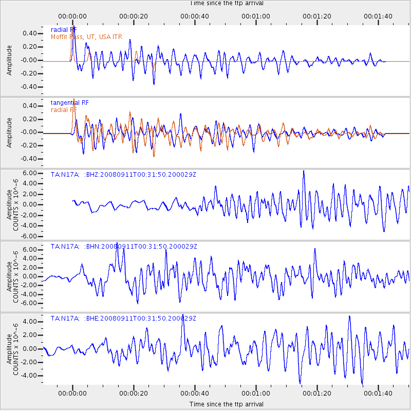
N17A Moffit Pass, UT, USA - Earthquake Result Viewer

| Earthquake location: |
Hokkaido, Japan Region |
| Earthquake latitude/longitude: |
41.9/143.8 |
| Earthquake time(UTC): |
2008/09/11 (255) 00:20:50 GMT |
| Earthquake Depth: |
25 km |
| Earthquake Magnitude: |
6.1 MB, 7.0 MS, 6.8 MW, 6.8 MW |
| Earthquake Catalog/Contributor: |
WHDF/NEIC |
|
| Network: |
TA USArray Transportable Network (new EarthScope stations) |
| Station: |
N17A Moffit Pass, UT, USA |
| Lat/Lon: |
40.94 N/110.83 W |
| Elevation: |
2500 m |
|
| Distance: |
73.5 deg |
| Az: |
49.61 deg |
| Baz: |
311.351 deg |
| Ray Param: |
0.052929368 |
| Estimated Moho Depth: |
44.5 km |
| Estimated Crust Vp/Vs: |
1.69 |
| Assumed Crust Vp: |
6.155 km/s |
| Estimated Crust Vs: |
3.642 km/s |
| Estimated Crust Poisson's Ratio: |
0.23 |
|
| Radial Match: |
83.82284 % |
| Radial Bump: |
400 |
| Transverse Match: |
84.08845 % |
| Transverse Bump: |
400 |
| SOD ConfigId: |
2560 |
| Insert Time: |
2010-03-06 18:48:00.803 +0000 |
| GWidth: |
2.5 |
| Max Bumps: |
400 |
| Tol: |
0.001 |
|
Signal To Noise
| Channel | StoN | STA | LTA |
| TA:N17A: :BHN:20080911T00:31:50.200029Z | 3.1984065 | 1.1381217E-6 | 3.5584023E-7 |
| TA:N17A: :BHE:20080911T00:31:50.200029Z | 0.923342 | 3.9552765E-7 | 4.2836527E-7 |
| TA:N17A: :BHZ:20080911T00:31:50.200029Z | 1.148652 | 7.0306635E-7 | 6.1207953E-7 |
| Arrivals |
| Ps | 5.2 SECOND |
| PpPs | 19 SECOND |
| PsPs/PpSs | 24 SECOND |


