You are here: Home > Network List > TA - USArray Transportable Network (new EarthScope stations) Stations List
> Station N17A Moffit Pass, UT, USA > Earthquake Result Viewer
N17A Moffit Pass, UT, USA - Earthquake Result Viewer
| Earthquake location: |
East Of Kuril Islands |
| Earthquake latitude/longitude: |
46.9/155.2 |
| Earthquake time(UTC): |
2009/01/15 (015) 17:49:39 GMT |
| Earthquake Depth: |
36 km |
| Earthquake Magnitude: |
6.9 MB, 7.5 MS, 7.4 MW, 7.4 MW |
| Earthquake Catalog/Contributor: |
WHDF/NEIC |
|
| Network: |
TA USArray Transportable Network (new EarthScope stations) |
| Station: |
N17A Moffit Pass, UT, USA |
| Lat/Lon: |
40.94 N/110.83 W |
| Elevation: |
2500 m |
|
| Distance: |
64.0 deg |
| Az: |
57.225 deg |
| Baz: |
310.387 deg |
| Ray Param: |
0.05914798 |
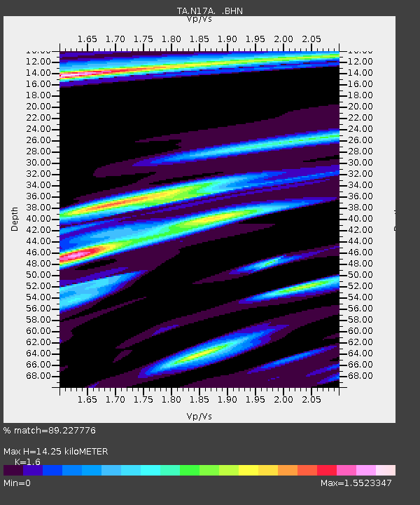
| Estimated Moho Depth: |
14.25 km |
| Estimated Crust Vp/Vs: |
1.60 |
| Assumed Crust Vp: |
6.155 km/s |
| Estimated Crust Vs: |
3.847 km/s |
| Estimated Crust Poisson's Ratio: |
0.18 |
|
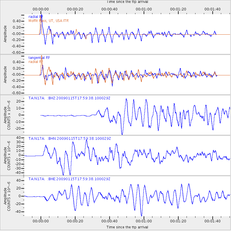
| Radial Match: |
89.227776 % |
| Radial Bump: |
400 |
| Transverse Match: |
80.907684 % |
| Transverse Bump: |
400 |
| SOD ConfigId: |
2834 |
| Insert Time: |
2010-03-06 18:48:03.261 +0000 |
| GWidth: |
2.5 |
| Max Bumps: |
400 |
| Tol: |
0.001 |
|
Signal To Noise
| Channel | StoN | STA | LTA |
| TA:N17A: :BHN:20090115T17:59:38.100029Z | 20.312387 | 1.1554533E-5 | 5.6884164E-7 |
| TA:N17A: :BHE:20090115T17:59:38.100029Z | 6.628675 | 5.056254E-6 | 7.62785E-7 |
| TA:N17A: :BHZ:20090115T17:59:38.100029Z | 10.340797 | 3.4746565E-6 | 3.3601438E-7 |
| Arrivals |
| Ps | 1.5 SECOND |
| PpPs | 5.8 SECOND |
| PsPs/PpSs | 7.2 SECOND |


