You are here: Home > Network List > TA - USArray Transportable Network (new EarthScope stations) Stations List
> Station N17A Moffit Pass, UT, USA > Earthquake Result Viewer
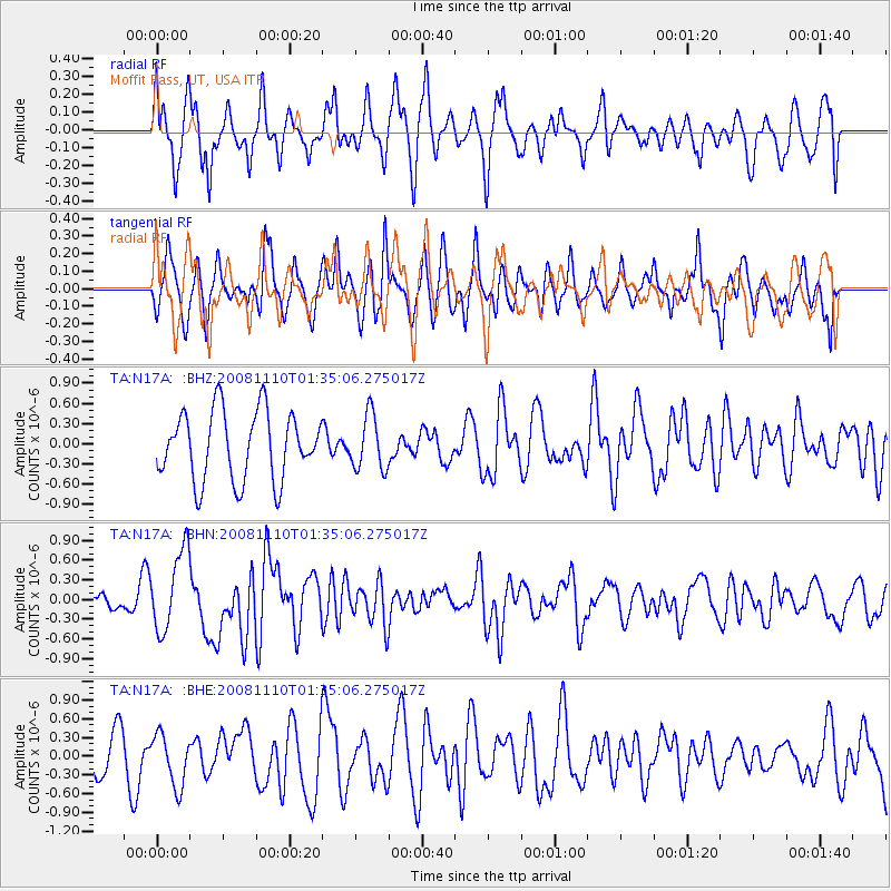
N17A Moffit Pass, UT, USA - Earthquake Result Viewer
*The percent match for this event was below the threshold and hence no stack was calculated.
| Earthquake location: |
Qinghai, China |
| Earthquake latitude/longitude: |
37.6/95.8 |
| Earthquake time(UTC): |
2008/11/10 (315) 01:22:02 GMT |
| Earthquake Depth: |
19 km |
| Earthquake Magnitude: |
6.4 MB, 6.4 MS, 6.3 MW, 6.3 MW |
| Earthquake Catalog/Contributor: |
WHDF/NEIC |
|
| Network: |
TA USArray Transportable Network (new EarthScope stations) |
| Station: |
N17A Moffit Pass, UT, USA |
| Lat/Lon: |
40.94 N/110.83 W |
| Elevation: |
2500 m |
|
| Distance: |
98.1 deg |
| Az: |
20.087 deg |
| Baz: |
338.884 deg |
| Ray Param: |
$rayparam |
*The percent match for this event was below the threshold and hence was not used in the summary stack. |
|
| Radial Match: |
54.51508 % |
| Radial Bump: |
400 |
| Transverse Match: |
65.93427 % |
| Transverse Bump: |
400 |
| SOD ConfigId: |
2658 |
| Insert Time: |
2010-03-06 18:48:50.296 +0000 |
| GWidth: |
2.5 |
| Max Bumps: |
400 |
| Tol: |
0.001 |
|
Signal To Noise
| Channel | StoN | STA | LTA |
| TA:N17A: :BHN:20081110T01:35:06.275017Z | 3.4208064 | 6.107586E-7 | 1.785423E-7 |
| TA:N17A: :BHE:20081110T01:35:06.275017Z | 0.8799665 | 4.2538858E-7 | 4.834145E-7 |
| TA:N17A: :BHZ:20081110T01:35:06.275017Z | 0.7998715 | 4.0661808E-7 | 5.083543E-7 |
| Arrivals |
| Ps | |
| PpPs | |
| PsPs/PpSs | |


