You are here: Home > Network List > TA - USArray Transportable Network (new EarthScope stations) Stations List
> Station B18K Kokolik River, AK, USA > Earthquake Result Viewer
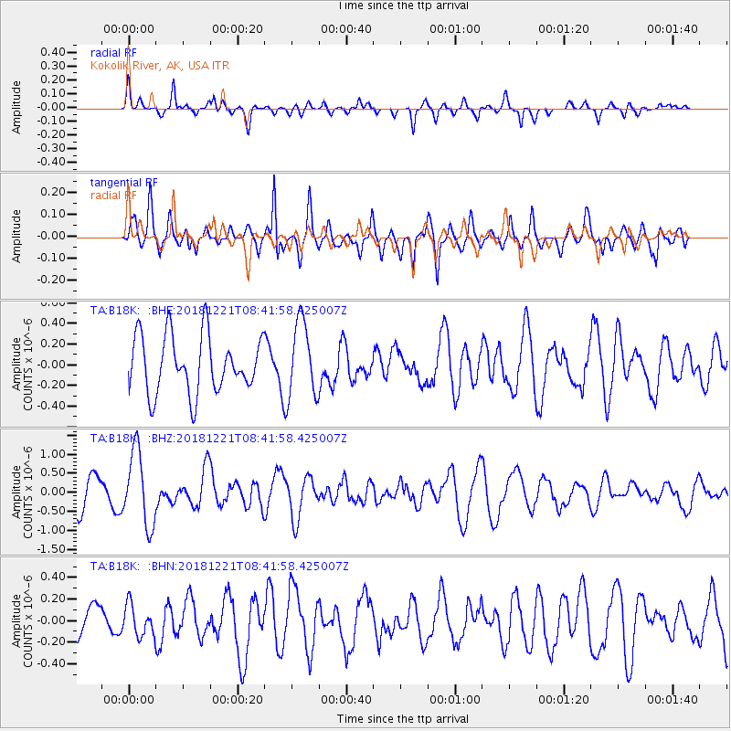
B18K Kokolik River, AK, USA - Earthquake Result Viewer
*The percent match for this event was below the threshold and hence no stack was calculated.
| Earthquake location: |
New Britain Region, P.N.G. |
| Earthquake latitude/longitude: |
-5.4/152.0 |
| Earthquake time(UTC): |
2018/12/21 (355) 08:30:15 GMT |
| Earthquake Depth: |
10 km |
| Earthquake Magnitude: |
5.7 Mww |
| Earthquake Catalog/Contributor: |
NEIC PDE/us |
|
| Network: |
TA USArray Transportable Network (new EarthScope stations) |
| Station: |
B18K Kokolik River, AK, USA |
| Lat/Lon: |
69.36 N/161.80 W |
| Elevation: |
222 m |
|
| Distance: |
81.0 deg |
| Az: |
15.017 deg |
| Baz: |
226.692 deg |
| Ray Param: |
$rayparam |
*The percent match for this event was below the threshold and hence was not used in the summary stack. |
|
| Radial Match: |
53.41908 % |
| Radial Bump: |
311 |
| Transverse Match: |
68.38217 % |
| Transverse Bump: |
385 |
| SOD ConfigId: |
13570011 |
| Insert Time: |
2019-05-02 03:04:54.139 +0000 |
| GWidth: |
2.5 |
| Max Bumps: |
400 |
| Tol: |
0.001 |
|
Signal To Noise
| Channel | StoN | STA | LTA |
| TA:B18K: :BHZ:20181221T08:41:58.425007Z | 2.772982 | 9.807741E-7 | 3.5368933E-7 |
| TA:B18K: :BHN:20181221T08:41:58.425007Z | 0.7245168 | 1.4535675E-7 | 2.0062578E-7 |
| TA:B18K: :BHE:20181221T08:41:58.425007Z | 1.3059117 | 3.6090665E-7 | 2.7636375E-7 |
| Arrivals |
| Ps | |
| PpPs | |
| PsPs/PpSs | |


