You are here: Home > Network List > TA - USArray Transportable Network (new EarthScope stations) Stations List
> Station D23K Nanushuk River, AK USA > Earthquake Result Viewer
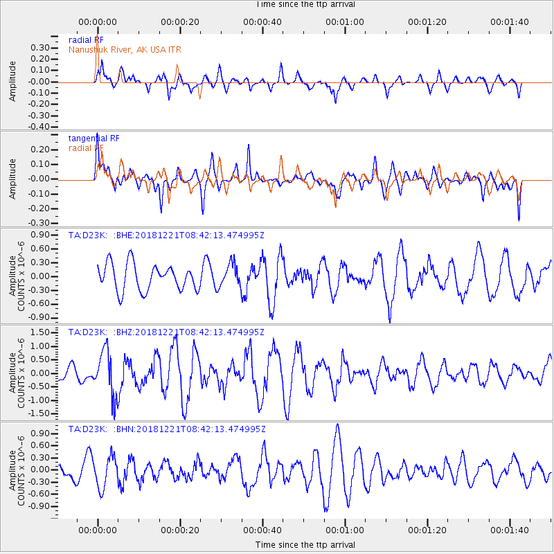
D23K Nanushuk River, AK USA - Earthquake Result Viewer
*The percent match for this event was below the threshold and hence no stack was calculated.
| Earthquake location: |
New Britain Region, P.N.G. |
| Earthquake latitude/longitude: |
-5.4/152.0 |
| Earthquake time(UTC): |
2018/12/21 (355) 08:30:15 GMT |
| Earthquake Depth: |
10 km |
| Earthquake Magnitude: |
5.7 Mww |
| Earthquake Catalog/Contributor: |
NEIC PDE/us |
|
| Network: |
TA USArray Transportable Network (new EarthScope stations) |
| Station: |
D23K Nanushuk River, AK USA |
| Lat/Lon: |
68.97 N/150.68 W |
| Elevation: |
406 m |
|
| Distance: |
83.9 deg |
| Az: |
17.798 deg |
| Baz: |
237.448 deg |
| Ray Param: |
$rayparam |
*The percent match for this event was below the threshold and hence was not used in the summary stack. |
|
| Radial Match: |
72.0883 % |
| Radial Bump: |
400 |
| Transverse Match: |
71.92883 % |
| Transverse Bump: |
400 |
| SOD ConfigId: |
13570011 |
| Insert Time: |
2019-05-02 03:04:57.160 +0000 |
| GWidth: |
2.5 |
| Max Bumps: |
400 |
| Tol: |
0.001 |
|
Signal To Noise
| Channel | StoN | STA | LTA |
| TA:D23K: :BHZ:20181221T08:42:13.474995Z | 2.3595607 | 8.728301E-7 | 3.6991213E-7 |
| TA:D23K: :BHN:20181221T08:42:13.474995Z | 1.7441654 | 3.84574E-7 | 2.2049171E-7 |
| TA:D23K: :BHE:20181221T08:42:13.474995Z | 0.8712778 | 2.4829535E-7 | 2.8497837E-7 |
| Arrivals |
| Ps | |
| PpPs | |
| PsPs/PpSs | |


