You are here: Home > Network List > TA - USArray Transportable Network (new EarthScope stations) Stations List
> Station E20K Nigu River, AK, USA > Earthquake Result Viewer
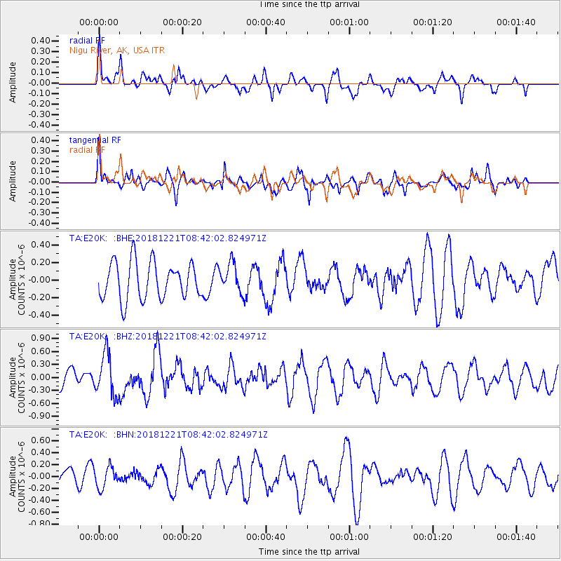
E20K Nigu River, AK, USA - Earthquake Result Viewer
*The percent match for this event was below the threshold and hence no stack was calculated.
| Earthquake location: |
New Britain Region, P.N.G. |
| Earthquake latitude/longitude: |
-5.4/152.0 |
| Earthquake time(UTC): |
2018/12/21 (355) 08:30:15 GMT |
| Earthquake Depth: |
10 km |
| Earthquake Magnitude: |
5.7 Mww |
| Earthquake Catalog/Contributor: |
NEIC PDE/us |
|
| Network: |
TA USArray Transportable Network (new EarthScope stations) |
| Station: |
E20K Nigu River, AK, USA |
| Lat/Lon: |
68.26 N/156.19 W |
| Elevation: |
866 m |
|
| Distance: |
81.8 deg |
| Az: |
17.211 deg |
| Baz: |
232.25 deg |
| Ray Param: |
$rayparam |
*The percent match for this event was below the threshold and hence was not used in the summary stack. |
|
| Radial Match: |
63.869053 % |
| Radial Bump: |
400 |
| Transverse Match: |
56.588257 % |
| Transverse Bump: |
376 |
| SOD ConfigId: |
13570011 |
| Insert Time: |
2019-05-02 03:04:58.333 +0000 |
| GWidth: |
2.5 |
| Max Bumps: |
400 |
| Tol: |
0.001 |
|
Signal To Noise
| Channel | StoN | STA | LTA |
| TA:E20K: :BHZ:20181221T08:42:02.824971Z | 2.3137255 | 5.0102653E-7 | 2.1654537E-7 |
| TA:E20K: :BHN:20181221T08:42:02.824971Z | 1.3545928 | 1.7246722E-7 | 1.2732035E-7 |
| TA:E20K: :BHE:20181221T08:42:02.824971Z | 0.80260503 | 1.7042568E-7 | 2.1234067E-7 |
| Arrivals |
| Ps | |
| PpPs | |
| PsPs/PpSs | |


