You are here: Home > Network List > TA - USArray Transportable Network (new EarthScope stations) Stations List
> Station N17A Moffit Pass, UT, USA > Earthquake Result Viewer
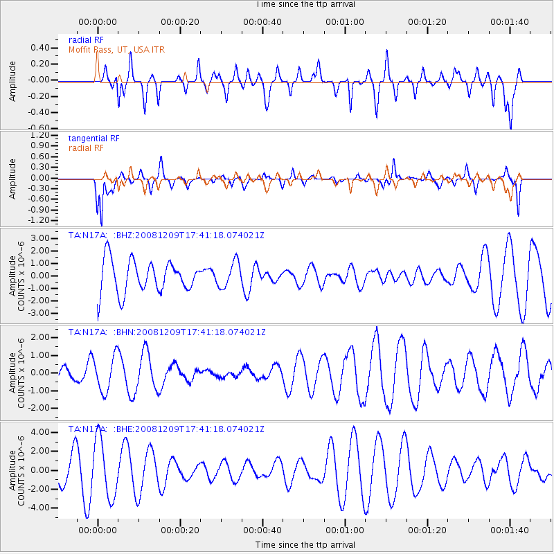
N17A Moffit Pass, UT, USA - Earthquake Result Viewer
*The percent match for this event was below the threshold and hence no stack was calculated.
| Earthquake location: |
Vanuatu Islands |
| Earthquake latitude/longitude: |
-15.9/168.2 |
| Earthquake time(UTC): |
2008/12/09 (344) 17:28:58 GMT |
| Earthquake Depth: |
224 km |
| Earthquake Magnitude: |
5.5 MB, 6.0 MW, 6.0 MW |
| Earthquake Catalog/Contributor: |
WHDF/NEIC |
|
| Network: |
TA USArray Transportable Network (new EarthScope stations) |
| Station: |
N17A Moffit Pass, UT, USA |
| Lat/Lon: |
40.94 N/110.83 W |
| Elevation: |
2500 m |
|
| Distance: |
93.7 deg |
| Az: |
48.567 deg |
| Baz: |
252.208 deg |
| Ray Param: |
$rayparam |
*The percent match for this event was below the threshold and hence was not used in the summary stack. |
|
| Radial Match: |
60.92253 % |
| Radial Bump: |
400 |
| Transverse Match: |
72.90099 % |
| Transverse Bump: |
400 |
| SOD ConfigId: |
2658 |
| Insert Time: |
2010-03-06 18:49:08.114 +0000 |
| GWidth: |
2.5 |
| Max Bumps: |
400 |
| Tol: |
0.001 |
|
Signal To Noise
| Channel | StoN | STA | LTA |
| TA:N17A: :BHN:20081209T17:41:18.074021Z | 3.335274 | 1.0057793E-6 | 3.0155823E-7 |
| TA:N17A: :BHE:20081209T17:41:18.074021Z | 2.853982 | 3.1527632E-6 | 1.1046893E-6 |
| TA:N17A: :BHZ:20081209T17:41:18.074021Z | 0.8074907 | 1.0327311E-6 | 1.2789386E-6 |
| Arrivals |
| Ps | |
| PpPs | |
| PsPs/PpSs | |


