You are here: Home > Network List > TA - USArray Transportable Network (new EarthScope stations) Stations List
> Station N17A Moffit Pass, UT, USA > Earthquake Result Viewer
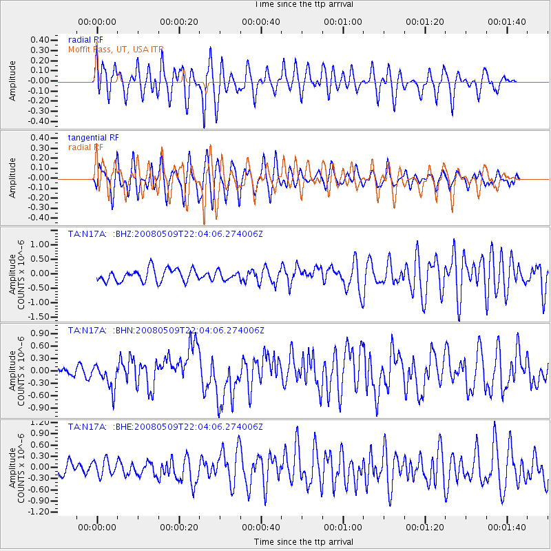
N17A Moffit Pass, UT, USA - Earthquake Result Viewer
*The percent match for this event was below the threshold and hence no stack was calculated.
| Earthquake location: |
South Of Mariana Islands |
| Earthquake latitude/longitude: |
12.5/143.2 |
| Earthquake time(UTC): |
2008/05/09 (130) 21:51:29 GMT |
| Earthquake Depth: |
76 km |
| Earthquake Magnitude: |
6.1 MB, 6.7 MW, 6.7 MW |
| Earthquake Catalog/Contributor: |
WHDF/NEIC |
|
| Network: |
TA USArray Transportable Network (new EarthScope stations) |
| Station: |
N17A Moffit Pass, UT, USA |
| Lat/Lon: |
40.94 N/110.83 W |
| Elevation: |
2500 m |
|
| Distance: |
93.6 deg |
| Az: |
46.862 deg |
| Baz: |
289.838 deg |
| Ray Param: |
$rayparam |
*The percent match for this event was below the threshold and hence was not used in the summary stack. |
|
| Radial Match: |
69.53253 % |
| Radial Bump: |
400 |
| Transverse Match: |
63.746292 % |
| Transverse Bump: |
400 |
| SOD ConfigId: |
2504 |
| Insert Time: |
2010-03-06 18:49:33.649 +0000 |
| GWidth: |
2.5 |
| Max Bumps: |
400 |
| Tol: |
0.001 |
|
Signal To Noise
| Channel | StoN | STA | LTA |
| TA:N17A: :BHN:20080509T22:04:06.274006Z | 3.7793658 | 3.1365565E-7 | 8.2991605E-8 |
| TA:N17A: :BHE:20080509T22:04:06.274006Z | 1.1291668 | 2.1381484E-7 | 1.8935629E-7 |
| TA:N17A: :BHZ:20080509T22:04:06.274006Z | 0.6531554 | 1.4158252E-7 | 2.1676696E-7 |
| Arrivals |
| Ps | |
| PpPs | |
| PsPs/PpSs | |


