You are here: Home > Network List > TA - USArray Transportable Network (new EarthScope stations) Stations List
> Station N17A Moffit Pass, UT, USA > Earthquake Result Viewer
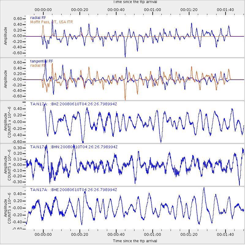
N17A Moffit Pass, UT, USA - Earthquake Result Viewer
*The percent match for this event was below the threshold and hence no stack was calculated.
| Earthquake location: |
Vanuatu Islands |
| Earthquake latitude/longitude: |
-18.1/167.9 |
| Earthquake time(UTC): |
2008/06/10 (162) 04:13:37 GMT |
| Earthquake Depth: |
35 km |
| Earthquake Magnitude: |
5.7 MS, 5.3 MB, 5.9 MW, 5.8 MW |
| Earthquake Catalog/Contributor: |
WHDF/NEIC |
|
| Network: |
TA USArray Transportable Network (new EarthScope stations) |
| Station: |
N17A Moffit Pass, UT, USA |
| Lat/Lon: |
40.94 N/110.83 W |
| Elevation: |
2500 m |
|
| Distance: |
95.3 deg |
| Az: |
48.765 deg |
| Baz: |
250.769 deg |
| Ray Param: |
$rayparam |
*The percent match for this event was below the threshold and hence was not used in the summary stack. |
|
| Radial Match: |
54.17231 % |
| Radial Bump: |
382 |
| Transverse Match: |
57.67945 % |
| Transverse Bump: |
261 |
| SOD ConfigId: |
2504 |
| Insert Time: |
2010-03-06 18:49:45.975 +0000 |
| GWidth: |
2.5 |
| Max Bumps: |
400 |
| Tol: |
0.001 |
|
Signal To Noise
| Channel | StoN | STA | LTA |
| TA:N17A: :BHN:20080610T04:26:26.798994Z | 1.3882797 | 1.8213454E-7 | 1.3119443E-7 |
| TA:N17A: :BHE:20080610T04:26:26.798994Z | 0.5854573 | 1.5753696E-7 | 2.6908359E-7 |
| TA:N17A: :BHZ:20080610T04:26:26.798994Z | 0.668605 | 1.7988586E-7 | 2.6904652E-7 |
| Arrivals |
| Ps | |
| PpPs | |
| PsPs/PpSs | |


