You are here: Home > Network List > TA - USArray Transportable Network (new EarthScope stations) Stations List
> Station N17A Moffit Pass, UT, USA > Earthquake Result Viewer
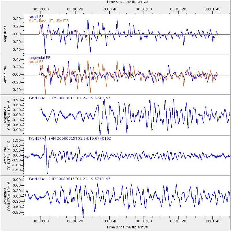
N17A Moffit Pass, UT, USA - Earthquake Result Viewer
*The percent match for this event was below the threshold and hence no stack was calculated.
| Earthquake location: |
Fiji Islands Region |
| Earthquake latitude/longitude: |
-17.7/-179.7 |
| Earthquake time(UTC): |
2008/06/15 (167) 01:13:11 GMT |
| Earthquake Depth: |
611 km |
| Earthquake Magnitude: |
5.5 MB, 5.9 MW, 5.9 MW |
| Earthquake Catalog/Contributor: |
WHDF/NEIC |
|
| Network: |
TA USArray Transportable Network (new EarthScope stations) |
| Station: |
N17A Moffit Pass, UT, USA |
| Lat/Lon: |
40.94 N/110.83 W |
| Elevation: |
2500 m |
|
| Distance: |
86.4 deg |
| Az: |
45.082 deg |
| Baz: |
242.986 deg |
| Ray Param: |
$rayparam |
*The percent match for this event was below the threshold and hence was not used in the summary stack. |
|
| Radial Match: |
76.69493 % |
| Radial Bump: |
400 |
| Transverse Match: |
73.53897 % |
| Transverse Bump: |
350 |
| SOD ConfigId: |
2504 |
| Insert Time: |
2010-03-06 18:49:46.964 +0000 |
| GWidth: |
2.5 |
| Max Bumps: |
400 |
| Tol: |
0.001 |
|
Signal To Noise
| Channel | StoN | STA | LTA |
| TA:N17A: :BHN:20080615T01:24:19.674019Z | 11.068027 | 9.008847E-7 | 8.139524E-8 |
| TA:N17A: :BHE:20080615T01:24:19.674019Z | 0.7219548 | 1.3194624E-7 | 1.8276246E-7 |
| TA:N17A: :BHZ:20080615T01:24:19.674019Z | 2.5085711 | 4.817797E-7 | 1.9205345E-7 |
| Arrivals |
| Ps | |
| PpPs | |
| PsPs/PpSs | |


