You are here: Home > Network List > TA - USArray Transportable Network (new EarthScope stations) Stations List
> Station N17A Moffit Pass, UT, USA > Earthquake Result Viewer
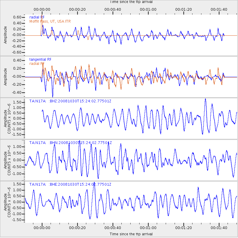
N17A Moffit Pass, UT, USA - Earthquake Result Viewer
*The percent match for this event was below the threshold and hence no stack was calculated.
| Earthquake location: |
Central East Pacific Rise |
| Earthquake latitude/longitude: |
-9.0/-108.2 |
| Earthquake time(UTC): |
2008/10/30 (304) 15:15:41 GMT |
| Earthquake Depth: |
10 km |
| Earthquake Magnitude: |
5.5 MB, 5.8 MS, 6.0 MW, 6.0 MW |
| Earthquake Catalog/Contributor: |
WHDF/NEIC |
|
| Network: |
TA USArray Transportable Network (new EarthScope stations) |
| Station: |
N17A Moffit Pass, UT, USA |
| Lat/Lon: |
40.94 N/110.83 W |
| Elevation: |
2500 m |
|
| Distance: |
49.8 deg |
| Az: |
357.433 deg |
| Baz: |
176.651 deg |
| Ray Param: |
$rayparam |
*The percent match for this event was below the threshold and hence was not used in the summary stack. |
|
| Radial Match: |
61.80082 % |
| Radial Bump: |
400 |
| Transverse Match: |
61.57321 % |
| Transverse Bump: |
367 |
| SOD ConfigId: |
2560 |
| Insert Time: |
2010-03-06 18:50:17.970 +0000 |
| GWidth: |
2.5 |
| Max Bumps: |
400 |
| Tol: |
0.001 |
|
Signal To Noise
| Channel | StoN | STA | LTA |
| TA:N17A: :BHN:20081030T15:24:02.77501Z | 1.790347 | 4.7065814E-7 | 2.6288654E-7 |
| TA:N17A: :BHE:20081030T15:24:02.77501Z | 0.9474212 | 2.8317675E-7 | 2.9889213E-7 |
| TA:N17A: :BHZ:20081030T15:24:02.77501Z | 0.47163787 | 2.3596601E-7 | 5.0031184E-7 |
| Arrivals |
| Ps | |
| PpPs | |
| PsPs/PpSs | |


