You are here: Home > Network List > TS - TERRAscope (Southern California Seismic Network) Stations List
> Station BAR Barrett Dam, California, USA > Earthquake Result Viewer
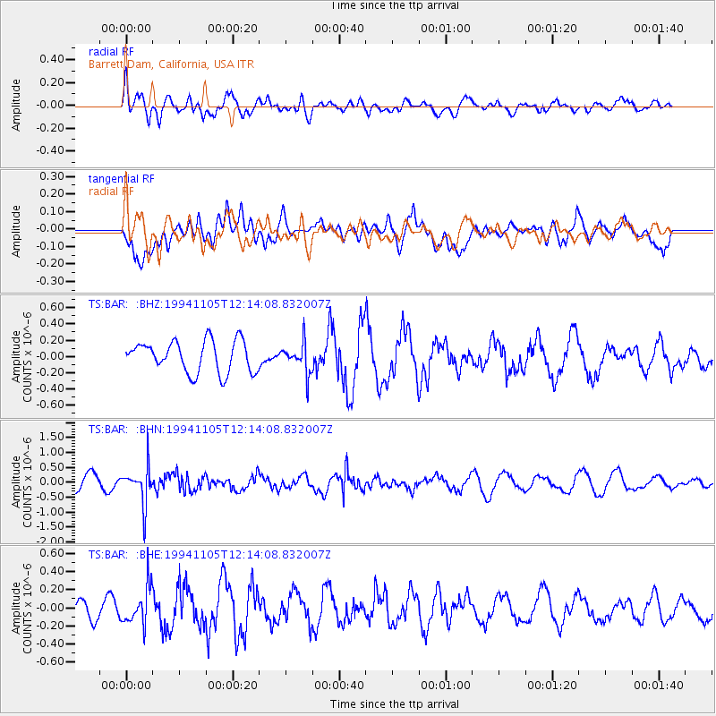
BAR Barrett Dam, California, USA - Earthquake Result Viewer
*The percent match for this event was below the threshold and hence no stack was calculated.
| Earthquake location: |
Peru-Brazil Border Region |
| Earthquake latitude/longitude: |
-9.3/-71.3 |
| Earthquake time(UTC): |
1994/11/05 (309) 12:05:28 GMT |
| Earthquake Depth: |
597 km |
| Earthquake Magnitude: |
5.6 MB, 5.8 UNKNOWN, 5.6 MW |
| Earthquake Catalog/Contributor: |
WHDF/NEIC |
|
| Network: |
TS TERRAscope (Southern California Seismic Network) |
| Station: |
BAR Barrett Dam, California, USA |
| Lat/Lon: |
32.68 N/116.67 W |
| Elevation: |
548 m |
|
| Distance: |
60.1 deg |
| Az: |
316.199 deg |
| Baz: |
125.897 deg |
| Ray Param: |
$rayparam |
*The percent match for this event was below the threshold and hence was not used in the summary stack. |
|
| Radial Match: |
35.69833 % |
| Radial Bump: |
375 |
| Transverse Match: |
51.54735 % |
| Transverse Bump: |
400 |
| SOD ConfigId: |
4480 |
| Insert Time: |
2010-02-26 14:02:18.624 +0000 |
| GWidth: |
2.5 |
| Max Bumps: |
400 |
| Tol: |
0.001 |
|
Signal To Noise
| Channel | StoN | STA | LTA |
| TS:BAR: :BHN:19941105T12:14:08.832007Z | 3.6502643 | 6.3120683E-7 | 1.7292085E-7 |
| TS:BAR: :BHE:19941105T12:14:08.832007Z | 1.5125465 | 2.1159778E-7 | 1.3989506E-7 |
| TS:BAR: :BHZ:19941105T12:14:08.832007Z | 0.9529902 | 1.8396014E-7 | 1.9303467E-7 |
| Arrivals |
| Ps | |
| PpPs | |
| PsPs/PpSs | |


