You are here: Home > Network List > TA - USArray Transportable Network (new EarthScope stations) Stations List
> Station E17A Martinsdale, MT, USA > Earthquake Result Viewer
E17A Martinsdale, MT, USA - Earthquake Result Viewer

| Earthquake location: |
Ryukyu Islands, Japan |
| Earthquake latitude/longitude: |
27.5/128.3 |
| Earthquake time(UTC): |
2008/07/08 (190) 07:42:10 GMT |
| Earthquake Depth: |
43 km |
| Earthquake Magnitude: |
6.0 MB, 5.5 MS, 6.0 MW, 6.0 MW |
| Earthquake Catalog/Contributor: |
WHDF/NEIC |
|
| Network: |
TA USArray Transportable Network (new EarthScope stations) |
| Station: |
E17A Martinsdale, MT, USA |
| Lat/Lon: |
46.46 N/110.86 W |
| Elevation: |
1835 m |
|
| Distance: |
89.0 deg |
| Az: |
36.428 deg |
| Baz: |
310.286 deg |
| Ray Param: |
0.042122416 |
| Estimated Moho Depth: |
69.75 km |
| Estimated Crust Vp/Vs: |
1.62 |
| Assumed Crust Vp: |
6.306 km/s |
| Estimated Crust Vs: |
3.899 km/s |
| Estimated Crust Poisson's Ratio: |
0.19 |
|
| Radial Match: |
90.61001 % |
| Radial Bump: |
400 |
| Transverse Match: |
79.463326 % |
| Transverse Bump: |
400 |
| SOD ConfigId: |
2504 |
| Insert Time: |
2010-03-06 18:50:27.508 +0000 |
| GWidth: |
2.5 |
| Max Bumps: |
400 |
| Tol: |
0.001 |
|
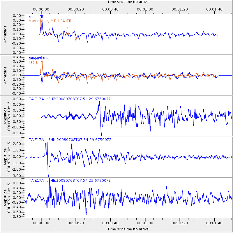
Signal To Noise
| Channel | StoN | STA | LTA |
| TA:E17A: :BHN:20080708T07:54:29.675007Z | 18.453125 | 1.2617357E-6 | 6.837518E-8 |
| TA:E17A: :BHE:20080708T07:54:29.675007Z | 2.8505912 | 2.2208016E-7 | 7.7906705E-8 |
| TA:E17A: :BHZ:20080708T07:54:29.675007Z | 5.2561936 | 3.7909987E-7 | 7.212441E-8 |
| Arrivals |
| Ps | 7.0 SECOND |
| PpPs | 28 SECOND |
| PsPs/PpSs | 35 SECOND |


