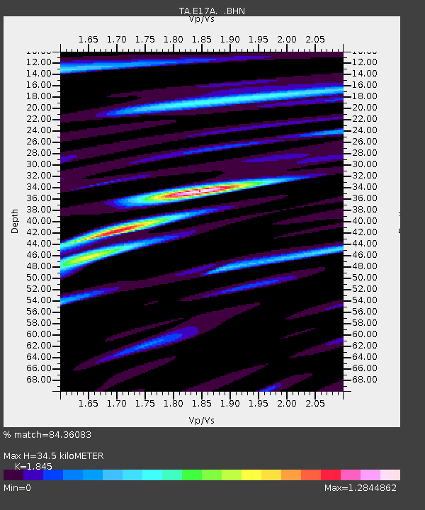
E17A Martinsdale, MT, USA - Earthquake Result Viewer

Earthquake location: Rat Islands, Aleutian Islands
Earthquake latitude/longitude: 51.3/179.0
Earthquake time(UTC): 2008/07/25 (207) 00:29:22 GMT
Earthquake Depth: 21 km
Earthquake Magnitude: 5.7 MB, 5.5 MS, 5.9 MW, 5.9 MW
Earthquake Catalog/Contributor: WHDF/NEIC
Network: TA USArray Transportable Network (new EarthScope stations)
Station: E17A Martinsdale, MT, USA
Lat/Lon: 46.46 N/110.86 W
Elevation: 1835 m
Distance: 44.8 deg
Az: 67.353 deg
Baz: 303.013 deg
Ray Param: 0.07166897
Estimated Moho Depth: 34.5 km
Estimated Crust Vp/Vs: 1.85
Assumed Crust Vp: 6.306 km/s
Estimated Crust Vs: 3.418 km/s
Estimated Crust Poisson's Ratio: 0.29
Radial Match: 84.36083 %
Radial Bump: 400
Transverse Match: 72.919655 %
Transverse Bump: 400
SOD ConfigId: 2504
Insert Time: 2010-03-06 18:50:38.697 +0000
GWidth: 2.5
Max Bumps: 400
Tol: 0.001

Signal To Noise

ChannelStoNSTALTA
TA:E17A: :BHN:20080725T00:37:04.350005Z8.7575055.93478E-76.776792E-8
TA:E17A: :BHE:20080725T00:37:04.350005Z4.0022531.8035722E-74.5063924E-8
TA:E17A: :BHZ:20080725T00:37:04.350005Z7.70063543.3415657E-74.3393374E-8
Arrivals
Ps4.9 SECOND
PpPs15 SECOND
PsPs/PpSs20 SECOND