You are here: Home > Network List > TA - USArray Transportable Network (new EarthScope stations) Stations List
> Station E17A Martinsdale, MT, USA > Earthquake Result Viewer
E17A Martinsdale, MT, USA - Earthquake Result Viewer
| Earthquake location: |
Sichuan, China |
| Earthquake latitude/longitude: |
32.8/105.5 |
| Earthquake time(UTC): |
2008/08/05 (218) 09:49:17 GMT |
| Earthquake Depth: |
6.0 km |
| Earthquake Magnitude: |
5.9 MB, 6.0 MS, 6.0 MW, 5.9 MW |
| Earthquake Catalog/Contributor: |
WHDF/NEIC |
|
| Network: |
TA USArray Transportable Network (new EarthScope stations) |
| Station: |
E17A Martinsdale, MT, USA |
| Lat/Lon: |
46.46 N/110.86 W |
| Elevation: |
1835 m |
|
| Distance: |
94.6 deg |
| Az: |
24.271 deg |
| Baz: |
329.929 deg |
| Ray Param: |
0.04101013 |
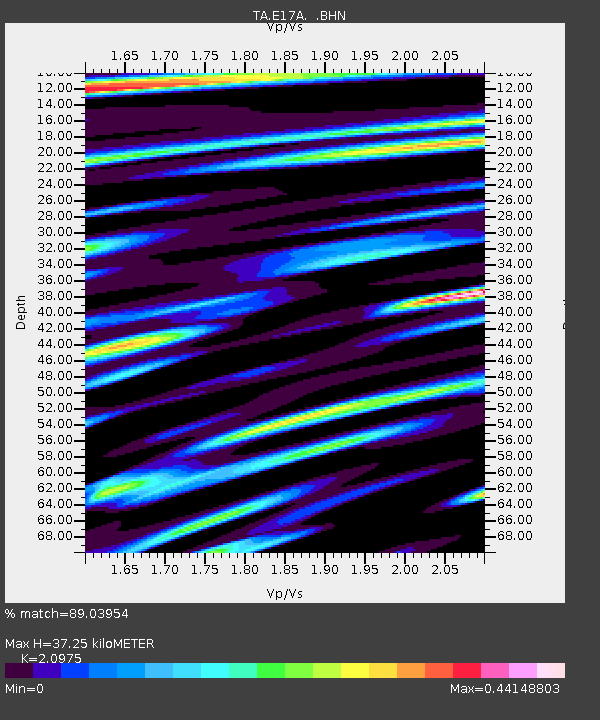
| Estimated Moho Depth: |
37.25 km |
| Estimated Crust Vp/Vs: |
2.10 |
| Assumed Crust Vp: |
6.306 km/s |
| Estimated Crust Vs: |
3.006 km/s |
| Estimated Crust Poisson's Ratio: |
0.35 |
|
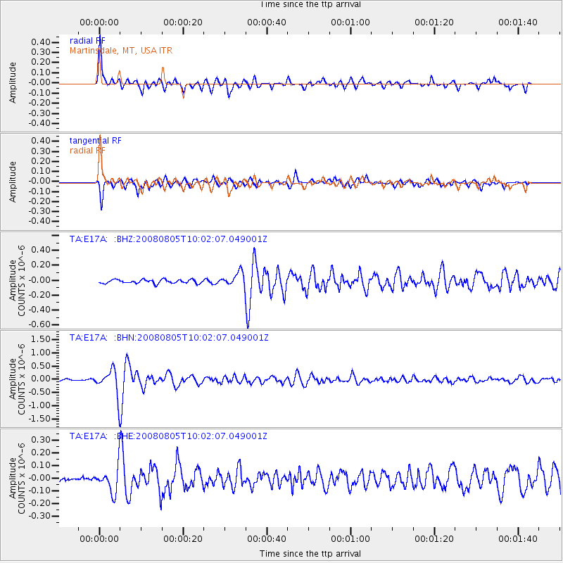
| Radial Match: |
89.03954 % |
| Radial Bump: |
400 |
| Transverse Match: |
85.018005 % |
| Transverse Bump: |
400 |
| SOD ConfigId: |
2504 |
| Insert Time: |
2010-03-06 18:50:40.281 +0000 |
| GWidth: |
2.5 |
| Max Bumps: |
400 |
| Tol: |
0.001 |
|
Signal To Noise
| Channel | StoN | STA | LTA |
| TA:E17A: :BHN:20080805T10:02:07.049001Z | 13.558367 | 4.9968554E-7 | 3.6854406E-8 |
| TA:E17A: :BHE:20080805T10:02:07.049001Z | 3.3333132 | 1.0325071E-7 | 3.09754E-8 |
| TA:E17A: :BHZ:20080805T10:02:07.049001Z | 3.8255174 | 9.413266E-8 | 2.4606516E-8 |
| Arrivals |
| Ps | 6.6 SECOND |
| PpPs | 18 SECOND |
| PsPs/PpSs | 25 SECOND |


