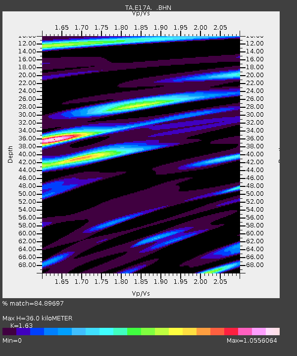
E17A Martinsdale, MT, USA - Earthquake Result Viewer
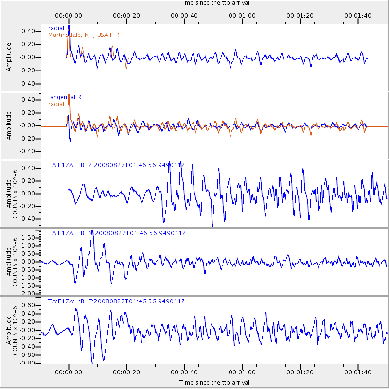
Earthquake location: Lake Baykal Region, Russia
Earthquake latitude/longitude: 51.6/104.2
Earthquake time(UTC): 2008/08/27 (240) 01:35:32 GMT
Earthquake Depth: 16 km
Earthquake Magnitude: 5.8 MB, 6.2 MS, 6.2 MW, 6.2 MW
Earthquake Catalog/Contributor: WHDF/NEIC
Network: TA USArray Transportable Network (new EarthScope stations)
Station: E17A Martinsdale, MT, USA
Lat/Lon: 46.46 N/110.86 W
Elevation: 1835 m
Distance: 77.8 deg
Az: 23.945 deg
Baz: 338.522 deg
Ray Param: 0.050085016
Estimated Moho Depth: 36.0 km
Estimated Crust Vp/Vs: 1.63
Assumed Crust Vp: 6.306 km/s
Estimated Crust Vs: 3.869 km/s
Estimated Crust Poisson's Ratio: 0.20
Radial Match: 84.89697 %
Radial Bump: 400
Transverse Match: 79.97201 %
Transverse Bump: 400
SOD ConfigId: 2504
Insert Time: 2010-03-06 18:50:46.433 +0000
GWidth: 2.5
Max Bumps: 400
Tol: 0.001

Signal To Noise

ChannelStoNSTALTA
TA:E17A: :BHN:20080827T01:46:56.949011Z9.3372785.839157E-76.253597E-8
TA:E17A: :BHE:20080827T01:46:56.949011Z3.20945262.7635E-78.6105025E-8
TA:E17A: :BHZ:20080827T01:46:56.949011Z3.4978762.3531E-76.727225E-8
Arrivals
Ps3.7 SECOND
PpPs15 SECOND
PsPs/PpSs18 SECOND