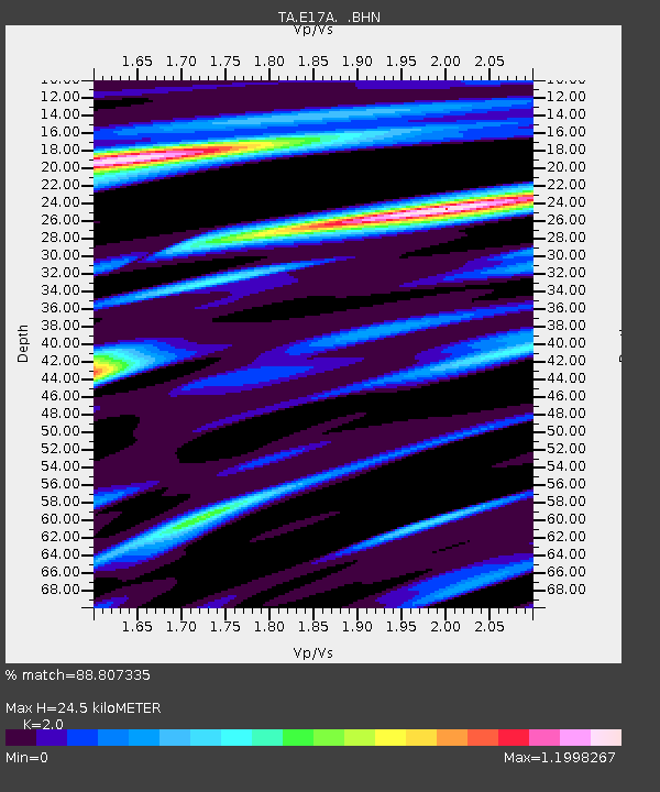
E17A Martinsdale, MT, USA - Earthquake Result Viewer
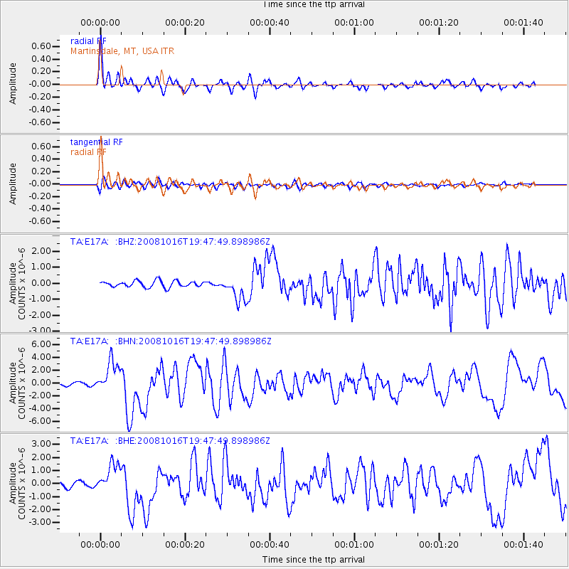
Earthquake location: Near Coast Of Chiapas, Mexico
Earthquake latitude/longitude: 14.4/-92.4
Earthquake time(UTC): 2008/10/16 (290) 19:41:25 GMT
Earthquake Depth: 24 km
Earthquake Magnitude: 6.1 MB, 6.6 MS, 6.7 MW, 6.6 MW
Earthquake Catalog/Contributor: WHDF/NEIC
Network: TA USArray Transportable Network (new EarthScope stations)
Station: E17A Martinsdale, MT, USA
Lat/Lon: 46.46 N/110.86 W
Elevation: 1835 m
Distance: 35.5 deg
Az: 337.821 deg
Baz: 148.054 deg
Ray Param: 0.0771494
Estimated Moho Depth: 24.5 km
Estimated Crust Vp/Vs: 2.00
Assumed Crust Vp: 6.306 km/s
Estimated Crust Vs: 3.153 km/s
Estimated Crust Poisson's Ratio: 0.33
Radial Match: 88.807335 %
Radial Bump: 400
Transverse Match: 73.82192 %
Transverse Bump: 400
SOD ConfigId: 2556
Insert Time: 2010-03-06 18:50:47.883 +0000
GWidth: 2.5
Max Bumps: 400
Tol: 0.001

Signal To Noise

ChannelStoNSTALTA
TA:E17A: :BHN:20081016T19:47:49.898986Z13.07556252.541596E-61.9437756E-7
TA:E17A: :BHE:20081016T19:47:49.898986Z6.2112171.1732036E-61.8888466E-7
TA:E17A: :BHZ:20081016T19:47:49.898986Z4.10821258.0494766E-71.9593624E-7
Arrivals
Ps4.1 SECOND
PpPs11 SECOND
PsPs/PpSs15 SECOND