You are here: Home > Network List > TA - USArray Transportable Network (new EarthScope stations) Stations List
> Station E17A Martinsdale, MT, USA > Earthquake Result Viewer
E17A Martinsdale, MT, USA - Earthquake Result Viewer
| Earthquake location: |
Near Coast Of Northern Chile |
| Earthquake latitude/longitude: |
-20.2/-70.0 |
| Earthquake time(UTC): |
2008/02/04 (035) 17:01:30 GMT |
| Earthquake Depth: |
44 km |
| Earthquake Magnitude: |
6.0 MB, 6.2 MS, 6.3 MW, 6.3 MW |
| Earthquake Catalog/Contributor: |
WHDF/NEIC |
|
| Network: |
TA USArray Transportable Network (new EarthScope stations) |
| Station: |
E17A Martinsdale, MT, USA |
| Lat/Lon: |
46.46 N/110.86 W |
| Elevation: |
1835 m |
|
| Distance: |
75.9 deg |
| Az: |
332.229 deg |
| Baz: |
140.712 deg |
| Ray Param: |
0.051289067 |
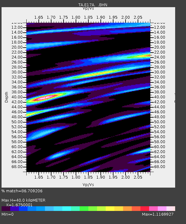
| Estimated Moho Depth: |
40.0 km |
| Estimated Crust Vp/Vs: |
1.68 |
| Assumed Crust Vp: |
6.306 km/s |
| Estimated Crust Vs: |
3.765 km/s |
| Estimated Crust Poisson's Ratio: |
0.22 |
|
| Radial Match: |
86.709206 % |
| Radial Bump: |
400 |
| Transverse Match: |
76.526825 % |
| Transverse Bump: |
400 |
| SOD ConfigId: |
2564 |
| Insert Time: |
2010-03-06 18:51:06.447 +0000 |
| GWidth: |
2.5 |
| Max Bumps: |
400 |
| Tol: |
0.001 |
|
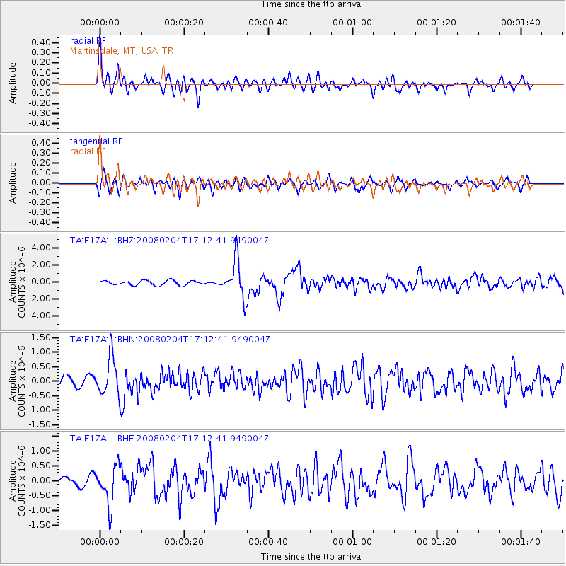
Signal To Noise
| Channel | StoN | STA | LTA |
| TA:E17A: :BHN:20080204T17:12:41.949004Z | 3.7590547 | 6.8169555E-7 | 1.8134762E-7 |
| TA:E17A: :BHE:20080204T17:12:41.949004Z | 4.3853626 | 6.698771E-7 | 1.5275295E-7 |
| TA:E17A: :BHZ:20080204T17:12:41.949004Z | 8.7745 | 2.311822E-6 | 2.6347053E-7 |
| Arrivals |
| Ps | 4.4 SECOND |
| PpPs | 16 SECOND |
| PsPs/PpSs | 21 SECOND |


