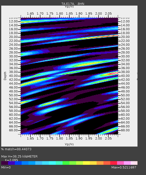
E17A Martinsdale, MT, USA - Earthquake Result Viewer
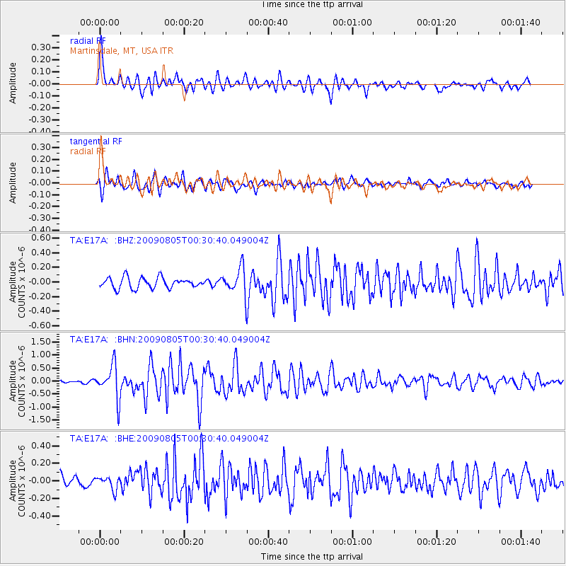
Earthquake location: Southwestern Ryukyu Isl., Japan
Earthquake latitude/longitude: 24.2/125.1
Earthquake time(UTC): 2009/08/05 (217) 00:17:58 GMT
Earthquake Depth: 25 km
Earthquake Magnitude: 5.9 MB, 5.9 MS, 6.2 MW, 6.1 MW
Earthquake Catalog/Contributor: WHDF/NEIC
Network: TA USArray Transportable Network (new EarthScope stations)
Station: E17A Martinsdale, MT, USA
Lat/Lon: 46.46 N/110.86 W
Elevation: 1835 m
Distance: 93.3 deg
Az: 35.012 deg
Baz: 310.738 deg
Ray Param: 0.041271843
Estimated Moho Depth: 38.25 km
Estimated Crust Vp/Vs: 2.10
Assumed Crust Vp: 6.306 km/s
Estimated Crust Vs: 3.01 km/s
Estimated Crust Poisson's Ratio: 0.35
Radial Match: 88.44073 %
Radial Bump: 400
Transverse Match: 83.68209 %
Transverse Bump: 400
SOD ConfigId: 2622
Insert Time: 2010-03-06 18:51:13.307 +0000
GWidth: 2.5
Max Bumps: 400
Tol: 0.001

Signal To Noise

ChannelStoNSTALTA
TA:E17A: :BHN:20090805T00:30:40.049004Z11.7054896.573108E-75.6154068E-8
TA:E17A: :BHE:20090805T00:30:40.049004Z1.07755357.59309E-87.046601E-8
TA:E17A: :BHZ:20090805T00:30:40.049004Z2.60384061.8852494E-77.240264E-8
Arrivals
Ps6.8 SECOND
PpPs18 SECOND
PsPs/PpSs25 SECOND