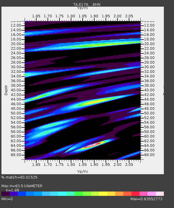
E17A Martinsdale, MT, USA - Earthquake Result Viewer

Earthquake location: Southwestern Ryukyu Isl., Japan
Earthquake latitude/longitude: 23.4/123.5
Earthquake time(UTC): 2009/08/17 (229) 10:10:55 GMT
Earthquake Depth: 10 km
Earthquake Magnitude: 5.9 MB, 6.2 MS, 6.1 MW, 6.1 MW
Earthquake Catalog/Contributor: WHDF/NEIC
Network: TA USArray Transportable Network (new EarthScope stations)
Station: E17A Martinsdale, MT, USA
Lat/Lon: 46.46 N/110.86 W
Elevation: 1835 m
Distance: 94.8 deg
Az: 34.33 deg
Baz: 311.461 deg
Ray Param: 0.040945
Estimated Moho Depth: 63.5 km
Estimated Crust Vp/Vs: 1.89
Assumed Crust Vp: 6.306 km/s
Estimated Crust Vs: 3.337 km/s
Estimated Crust Poisson's Ratio: 0.31
Radial Match: 80.01525 %
Radial Bump: 400
Transverse Match: 56.34838 %
Transverse Bump: 400
SOD ConfigId: 2622
Insert Time: 2010-03-06 18:51:26.616 +0000
GWidth: 2.5
Max Bumps: 400
Tol: 0.001

Signal To Noise

ChannelStoNSTALTA
TA:E17A: :BHN:20090817T10:23:45.925007Z2.78367661.9174128E-76.888059E-8
TA:E17A: :BHE:20090817T10:23:45.925007Z1.03083176.7418995E-86.5402524E-8
TA:E17A: :BHZ:20090817T10:23:45.925007Z1.41022677.0275824E-84.9833E-8
Arrivals
Ps9.1 SECOND
PpPs29 SECOND
PsPs/PpSs38 SECOND